File:Europe-Isle of Man.svg

Dimension de iste previsualisation PNG de iste file SVG: 713 × 600 pixels. Altere resolutiones: 285 × 240 pixels | 571 × 480 pixels | 913 × 768 pixels | 1 218 × 1 024 pixels | 2 435 × 2 048 pixels | 2 045 × 1 720 pixels.
File original (File SVG, dimensiones nominal: 2 045 × 1 720 pixels, grandor del file: 2,24 MB)
Summario
| Description |
English:
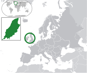
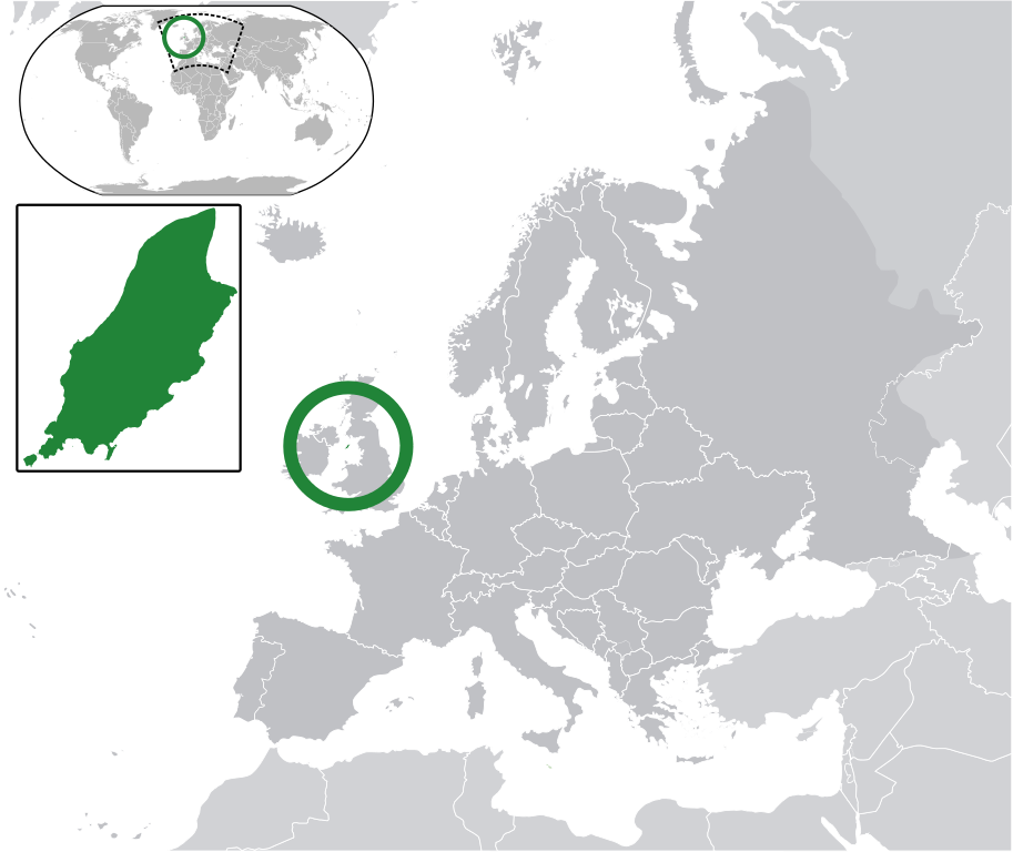
Map in English of the Isle of Man, with bounds of sheadings, towns, villages, districts and parishes. (Green) Isle of Man.
(Gray) Europe.
(Light-gray) The surrounding region.
The Full Map of the Isle of Man |
||
| Data | |||
| Origine | Own work based on: IsleOfMan SheadingsAndParishes-en.svg | ||
| Autor | Chipmunkdavis | ||
| Permission (Reuso de iste file) |
Iste file es disponibile sub le licentia Creative Commons Attribution-CompartiSimile 3.0 Non-localisate.
|
||
| SVG genesis |
|
Registro de incargamento original
This image is a derivative work of the following images:
- licensed with Cc-by-sa-3.0
- 2011-02-21T07:49:57Z Chipmunkdavis 2045x1720 (2394864 Bytes)
- IsleOfMan SheadingsAndParishes-en.svg licensed with Cc-by-sa-3.0,2.5,2.0,1.0, GFDL
- 2008-01-17T12:48:28Z Sémhur 1200x1100 (227618 Bytes) Update
- 2007-05-29T20:36:04Z Sémhur 0x0 (364350 Bytes) {{Information |Description=Map in English of the [[:en:Isle of Man|Isle of Man]], with bounds of sheadings, towns, villages, districts and parishes. |Source=Own work. Based on maps [[:Image:Isle of Man map-fr.svg]], [[:Image:
Uploaded with derivativeFX
Historia del file
Clicca sur un data/hora pro vider le file como appareva a ille tempore.
| Data/Hora | Miniatura | Dimensiones | Usator | Commento | |
|---|---|---|---|---|---|
| actual | 06:10, 2 martio 2011 | | 2 045 × 1 720 (2,24 MB) | Chipmunkdavis | Redid inset |
| 06:03, 2 martio 2011 |  | 2 045 × 1 720 (2,22 MB) | Chipmunkdavis | Without inset | |
| 06:01, 2 martio 2011 |  | 2 045 × 1 720 (2,22 MB) | Chipmunkdavis | One more try | |
| 09:03, 21 februario 2011 |  | 2 045 × 1 720 (2,22 MB) | Chipmunkdavis | Grouped inset | |
| 09:00, 21 februario 2011 |  | 2 045 × 1 720 (2,22 MB) | Chipmunkdavis | File not appearing properly, reuploading | |
| 08:06, 21 februario 2011 |  | 2 045 × 1 720 (2,22 MB) | Chipmunkdavis | {{Information |Description={{en|1={{Europe-SVG-en|Northern Cyprus}}}} {{en|1=The Full Map of Jersey}} Map in english of the Isle of Man, with bounds of sheadings, towns, villages, districts and parishes. |Source=*[[:File:Europe-Jersey. |
Uso de iste file
Le sequente 3 paginas usa iste file:
Uso global de iste file
Le altere wikis sequente usa iste imagine:
- Uso in ace.wikipedia.org
- Uso in an.wikipedia.org
- Uso in ar.wikipedia.org
- Uso in arz.wikipedia.org
- Uso in ast.wikipedia.org
- Uso in az.wikipedia.org
- Uso in ba.wikipedia.org
- Uso in bg.wikipedia.org
- Uso in bh.wikipedia.org
- Uso in bn.wikipedia.org
- Uso in ca.wikipedia.org
- Uso in cdo.wikipedia.org
- Uso in cs.wikipedia.org
- Uso in diq.wikipedia.org
- Uso in en.wikipedia.org
- Uso in eo.wikipedia.org
- Uso in es.wikipedia.org
- Uso in ext.wikipedia.org
- Uso in fi.wiktionary.org
- Uso in fr.wikipedia.org
- Uso in ga.wikipedia.org
- Uso in gl.wikipedia.org
- Uso in hak.wikipedia.org
- Uso in ha.wikipedia.org
- Uso in he.wikipedia.org
- Uso in incubator.wikimedia.org
- Uso in it.wikipedia.org
- Uso in ja.wikipedia.org
- Uso in kab.wikipedia.org
- Uso in kk.wikipedia.org
- Uso in km.wikipedia.org
- Uso in la.wikipedia.org
- Uso in lb.wikipedia.org
- Uso in lij.wikipedia.org
- Uso in lv.wikipedia.org
- Uso in mk.wikipedia.org
- Uso in my.wikipedia.org
- Uso in nds.wikipedia.org
- Uso in nl.wikipedia.org
Vider altere usos global de iste file.