File:Iron Curtain map.svg

Dimension de iste previsualisation PNG de iste file SVG: 560 × 599 pixels. Altere resolutiones: 224 × 240 pixels | 449 × 480 pixels | 718 × 768 pixels | 957 × 1 024 pixels | 1 914 × 2 048 pixels | 645 × 690 pixels.
File original (File SVG, dimensiones nominal: 645 × 690 pixels, grandor del file: 322 KB)
Summario
| Description |
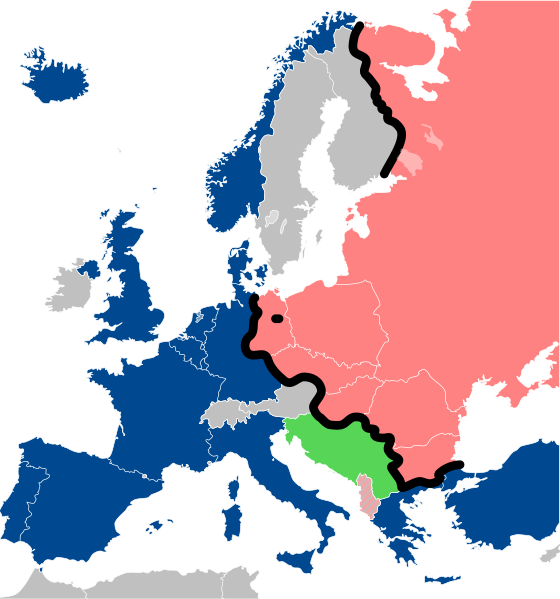
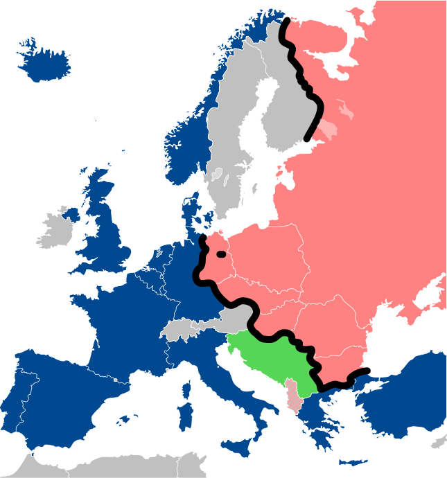
Lëtzebuergesch: Kaart vum Westen an dem Ostblock an Europa während dem Kale Krich.
"Eise Rido"
Neutral Länner
|
||
| Data | |||
| Origine |
Travail personnel (own work). Sources:
|
||
| Autor | Sémhur | ||
| Altere versiones |
File:Iron Curtain map alternative.svg (Same, but with Yugoslavia on the Eastern side of the Iron Curtain.) | ||
| Attribution (required by the license) | © Sémhur / Wikimedia Commons / | ||
| SVG | W3C-validity not checked.
|
||
| Graphic Lab |

| Camera location | | View this and other nearby images on: OpenStreetMap |
|---|
Licentia
Io, titular del derecto de autor sur iste obra, declara de publicar lo sub le sequente licentias:
| Copyleft: Iste obra de arte es libere; tu pote redistribuer lo e/o modificar lo secundo le conditiones del Licentia Arte Libere. Un specimen de iste licentia se trova in le sito Copyleft Attitude e in altere sitos. |
Iste file es disponibile sub le licentias Creative Commons Attribution-CompartiSimile 4.0 International, 3.0 Non localisate, 2.5 Generic, 2.0 Generic e 1.0 Generic.
- Tu es libere:
- de condivider – de copiar, distribuer e transmitter le obra
- de remixar – de adaptar le obra
- Sub le sequente conditiones:
- attribution – Tu debe dar information appropriate sur le autor, fornir un ligamine al licentia, e indicar si modificationes ha essite apportate. Tu pote facer lo de qualcunque maniera rationabile, ma non in alcun modo que suggere que le licentiator approba te o tu uso del obra.
- condivider equalmente – Si tu altera, transforma o disveloppa le material, tu debe distribuer tu contributiones sub un licentia identic o compatibile con le original.
Tu pote seliger le licentia de tu preferentia.
Historia del file
Clicca sur un data/hora pro vider le file como appareva a ille tempore.
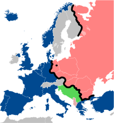
| Data/Hora | Miniatura | Dimensiones | Usator | Commento | |
|---|---|---|---|---|---|
| actual | 13:26, 15 decembre 2022 | | 645 × 690 (322 KB) | PhotographyEdits | Extend the Iron Curtain eastwards of Yugoslavia. Even though Yugoslavia was not really considered part of the West, the currenet map gives the false impression that there was a huge gap in the Iron Curtain, which wasn't the case. |
| 00:56, 23 julio 2022 |  | 645 × 690 (321 KB) | Kwamikagami | NATO blue, #004990 | |
| 20:30, 30 martio 2019 |  | 645 × 690 (321 KB) | Sémhur | Reverted to version as of 07:07, 27 May 2014 (UTC). Albania leaves the Waras Pack in middle of cold war; this is why it's shown wtih stripes. | |
| 09:18, 24 martio 2019 |  | 512 × 548 (123 KB) | Hakuli | Albania leaves the Waras Pack in middle of cold war | |
| 07:07, 27 maio 2014 |  | 645 × 690 (321 KB) | Sémhur | Valid SVG | |
| 13:51, 16 novembre 2010 |  | 645 × 690 (321 KB) | Sémhur | Added Iron Curtain between Bulgaria and Greece & Turkey. | |
| 16:57, 27 septembre 2008 |  | 645 × 690 (321 KB) | Sémhur | Correcting mistake : Austria wasn't in NATO. | |
| 10:51, 31 maio 2008 |  | 645 × 690 (330 KB) | Sémhur | {{Information |Description={{en|1=Map of the Iron Curtain in Europe.}} {{fr|1=Carte du rideau de fer en Europe.}} {{es|1=Mapa del Telón de Acero en Europa.}} |Source=Travail personnel (ow |
Uso de iste file
Le sequente pagina usa iste file:
Uso global de iste file
Le altere wikis sequente usa iste imagine:
- Uso in af.wikipedia.org
- Uso in als.wikipedia.org
- Uso in ar.wikipedia.org
- Uso in ast.wikipedia.org
- Uso in azb.wikipedia.org
- Uso in az.wikipedia.org
- Uso in ba.wikipedia.org
- Uso in be-tarask.wikipedia.org
- Uso in be.wikipedia.org
- Uso in bg.wikipedia.org
- Uso in br.wikipedia.org
- Uso in bs.wikipedia.org
- Uso in ca.wikipedia.org
- Uso in cs.wikipedia.org
- Uso in cy.wikipedia.org
- Uso in da.wikipedia.org
- Uso in de.wikipedia.org
- Uso in el.wikipedia.org
- Uso in el.wiktionary.org
- Uso in en.wikipedia.org
- Uso in en.wikibooks.org
- Uso in en.wikiquote.org
Vider altere usos global de iste file.