File:2011-P02-Friesland-b54.jpg

Dimension de iste previsualisation: 751 × 600 pixels.Altere resolutiones: 301 × 240 pixels | 601 × 480 pixels | 962 × 768 pixels | 1 280 × 1 022 pixels | 1 625 × 1 298 pixels.
File original (1 625 × 1 298 pixels, dimension del file: 1,03 MB, typo MIME: image/jpeg)
Summario
| Description |
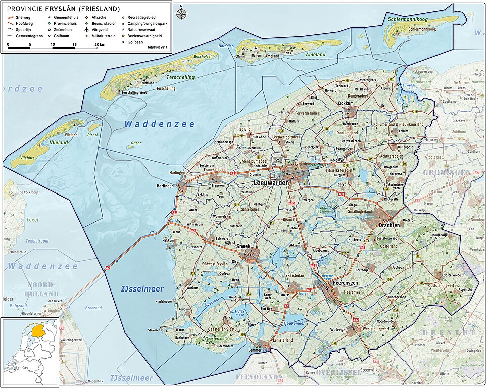
Nederlands: Provincie Fryslân (Friesland), met indeling van gemeenten (2011) en impressie van het landschap.
Door Jan-Willem van Aalst, samengesteld uit publiek beschikbare geo-data:
|
| Data | |
| Origine | Obra proprie |
| Autor | Janwillemvanaalst |
| Altere versiones | 2009-Basisbeeld-Provincie02-Fryslan.jpg; 2010-P02-Fryslan-basisbeeld.jpg |
Licentia
Io, titular del derecto de autor sur iste obra, declara de publicar lo sub le sequente licentia:
Iste file es disponibile sub le licentia Creative Commons Attribution-CompartiSimile 3.0 Non-localisate.
- Tu es libere:
- de condivider – de copiar, distribuer e transmitter le obra
- de remixar – de adaptar le obra
- Sub le sequente conditiones:
- attribution – Tu debe dar information appropriate sur le autor, fornir un ligamine al licentia, e indicar si modificationes ha essite apportate. Tu pote facer lo de qualcunque maniera rationabile, ma non in alcun modo que suggere que le licentiator approba te o tu uso del obra.
- condivider equalmente – Si tu altera, transforma o disveloppa le material, tu debe distribuer tu contributiones sub un licentia identic o compatibile con le original.
Historia del file
Clicca sur un data/hora pro vider le file como appareva a ille tempore.
| Data/Hora | Miniatura | Dimensiones | Usator | Commento | |
|---|---|---|---|---|---|
| actual | 05:52, 5 junio 2011 | | 1 625 × 1 298 (1,03 MB) | Janwillemvanaalst | Added various village/town names |
| 06:49, 15 maio 2011 |  | 1 622 × 1 296 (1,03 MB) | Janwillemvanaalst | Revision of sea and coastline; updated infrastructure (local roads) and points of interest (added WTC Expo center, Leeuwarden) | |
| 07:05, 24 april 2011 |  | 1 541 × 1 231 (973 KB) | Janwillemvanaalst | Updates of names, recreation locations, roads | |
| 16:52, 9 martio 2011 |  | 1 541 × 1 231 (948 KB) | Janwillemvanaalst | Added public health services; added regional road labels (N-roads) | |
| 18:59, 23 februario 2011 |  | 1 541 × 1 231 (938 KB) | Janwillemvanaalst | Added local airports; Added Golf courses; Added major city parks. | |
| 08:39, 13 februario 2011 |  | 1 541 × 1 231 (933 KB) | Janwillemvanaalst | Various map updates and some omissions corrected. Added various tourist locations. | |
| 11:06, 31 decembre 2010 |  | 1 460 × 1 166 (793 KB) | Janwillemvanaalst | {{Information |Description={{nl|1=Provincie Fryslân (Friesland), met indeling van gemeenten (2011) en impressie van het landschap. Door Jan-Willem van Aalst, samengesteld uit publiek beschikbare geo-data: * Referentie-ondergrond (kustlijn, steden, wegen) |
Uso de iste file
Il non ha paginas que usa iste file.
Uso global de iste file
Le altere wikis sequente usa iste imagine:
- Uso in el.wikipedia.org
- Uso in fy.wikipedia.org
- Uso in is.wikipedia.org
- Uso in nl.wikipedia.org
- Uso in ru.wikipedia.org