File:Atlas Van der Hagen-KW1049B12 002-HISPANIAE ET PORTUGALIAE REGNA.jpeg
Dimension de iste previsualisation: 723 × 600 pixels.Altere resolutiones: 289 × 240 pixels | 579 × 480 pixels | 926 × 768 pixels | 1 234 × 1 024 pixels | 2 469 × 2 048 pixels | 5 500 × 4 563 pixels.
File original (5 500 × 4 563 pixels, dimension del file: 4,31 MB, typo MIME: image/jpeg)
Summario
| Dirk Jansz van Santen: Atlas van Dirk van der Hagen (volledig, collectie KB)
|
||||||||||||||||||||||||||||||||||||||||||||||||||||
|---|---|---|---|---|---|---|---|---|---|---|---|---|---|---|---|---|---|---|---|---|---|---|---|---|---|---|---|---|---|---|---|---|---|---|---|---|---|---|---|---|---|---|---|---|---|---|---|---|---|---|---|---|
| Artista |
Author: Nicolaes Visscher II Publisher:
|
 | ||||||||||||||||||||||||||||||||||||||||||||||||||
| Autor |
Author: Nicolaes Visscher II Publisher:
|
|||||||||||||||||||||||||||||||||||||||||||||||||||
| Titulo |
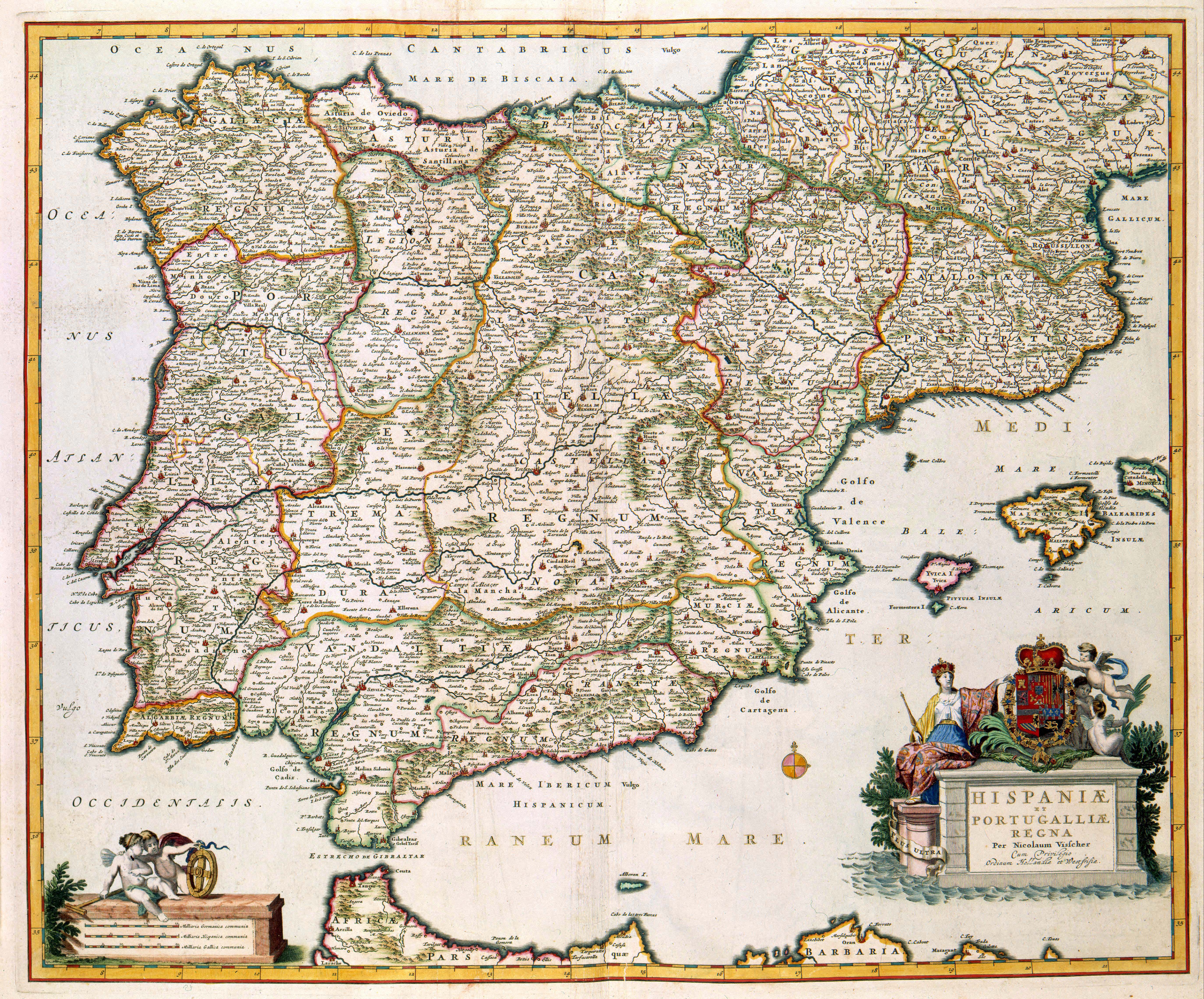
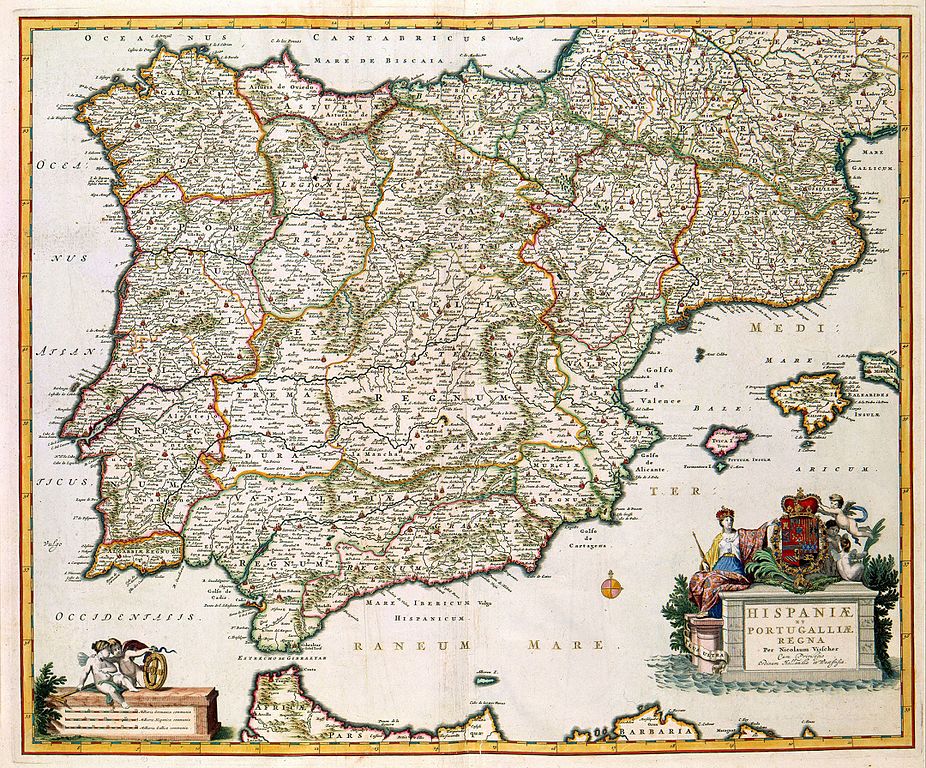
HISPANIAE ET PORTUGALIAE REGNA |
|||||||||||||||||||||||||||||||||||||||||||||||||||
| Object type | mappa | |||||||||||||||||||||||||||||||||||||||||||||||||||
| Description |
Nederlands: Deze kaart van Spanje en Portugal werd gepubliceerd door Nicolaes Visscher II (1649-1702). Het was zeker niet de eerste uitgave van de kaart. De kaart was in 1631 voor het eerst door Willem Jansz. Blaeu (1571-1638) uitgegeven, toen onder de titel: Regnorum Hispaniae. Spanje en Portugal vormden namelijk tot 1640 één koninkrijk. Toen aan deze situatie een einde kwam werd ook de titel aangepast aan de veranderde politieke situatie.
English: This map of Spain and Portugal was published by Nicolaes Visscher II (1649-1702). It was not the first issue of the map. In 1631 the map was first printed by Willem Jansz. Blaeu (1571-1638), under the title: Regnorum Hispaniae because Spain and Portugal formed one kingdom until 1640. When this ended the title had to be adapted to the new political situation. |
|||||||||||||||||||||||||||||||||||||||||||||||||||
| Lingua |
nederlandese |
|||||||||||||||||||||||||||||||||||||||||||||||||||
| Data | after 1681 | |||||||||||||||||||||||||||||||||||||||||||||||||||
| Publication date |
circa |
|||||||||||||||||||||||||||||||||||||||||||||||||||
| Technica/Material |
Nederlands: kopergravure
English: copper engraving print |
|||||||||||||||||||||||||||||||||||||||||||||||||||
| Dimensiones | 46 x 57 cm | |||||||||||||||||||||||||||||||||||||||||||||||||||
| Collection |
|
|||||||||||||||||||||||||||||||||||||||||||||||||||
| Numero de accession |
Description of the Atlas Van der Hagen in the catalogue of the KB: http://opc4.kb.nl/DB=1/TTL=1/LNG=EN/PPN?PPN=353012750 |
|||||||||||||||||||||||||||||||||||||||||||||||||||
| Place of creation | Amsterdam | |||||||||||||||||||||||||||||||||||||||||||||||||||
| Notas | KW1049B12_002 - Volume 1 | |||||||||||||||||||||||||||||||||||||||||||||||||||
| Related persons | Nicolaes Visscher II - Willem Jansz. Blaeu | |||||||||||||||||||||||||||||||||||||||||||||||||||
| Depicted locations | Spain - Portugal | |||||||||||||||||||||||||||||||||||||||||||||||||||
| Referentias | ||||||||||||||||||||||||||||||||||||||||||||||||||||
| Fonte/Photographo |
Source page at the [1]; Geheugen van Nederland / Memory of the Netherlands website.
|
|||||||||||||||||||||||||||||||||||||||||||||||||||
| Permission (Reuso de iste file) |
|
|||||||||||||||||||||||||||||||||||||||||||||||||||

Historia del file
Clicca sur un data/hora pro vider le file como appareva a ille tempore.
| Data/Hora | Miniatura | Dimensiones | Usator | Commento | |
|---|---|---|---|---|---|
| actual | 11:00, 18 julio 2015 | | 5 500 × 4 563 (4,31 MB) | OlafJanssen | GWToolset: Creating mediafile for OlafJanssen. |
Uso de iste file
Le sequente pagina usa iste file:
Uso global de iste file
Le altere wikis sequente usa iste imagine:
- Uso in ar.wikipedia.org
- إسبانيا
- الحرب الأهلية الإسبانية
- حرب الريف (1920–1927)
- سقوط الأندلس
- تاريخ إسبانيا
- حرب الخلافة الإسبانية
- الملكان الكاثوليكيان
- هسبانيا
- الإمبراطورية الإسبانية
- الفتح الإسلامي للأندلس
- الحرب الأمريكية الإسبانية
- إسبانيا هابسبورغ
- الجبهة الشعبية (إسبانيا)
- حرب غرناطة
- مملكة القوط الغربيين
- الاستعمار الإسباني للأمريكيتين
- العصر الذهبي الإسباني
- الحرب الكارلية الثالثة
- الحرب الكارلية الأولى
- مراسيم نويفا بلانتا
- حكم الثلاث سنوات الليبرالي
- العشرية المشؤومة
- دستور إسبانيا 1812
- كاتدرائيات إسبانيا
- الثورة المجيدة في إسبانيا
- مجلس قادس
- قالب:تاريخ إسبانيا
- كونفرسوس
- إسبانيا في القرن 17
- التسلسل الزمني لتاريخ إسبانيا
- التنوير في إسبانيا
- إصلاحات البوربون
- تاريخ إسبانيا العسكري
- مملكة إسبانيا النابليونية
- تاريخ إسبانيا (1810–1873)
- تاريخ إسبانيا الحديث
- الحياة السياسية في إسبانيا خلال فترة وصاية ماريا كريستينا البوربونية
- الحياة السياسية في إسبانيا خلال فترة وصاية بالدوميرو إسبارتيرو
- العشرية المعتدلة
- سنتا التقدميين
- حكومة الاتحاد الليبرالي
- الأزمة الأخيرة من عهد إيزابيل الثانية
- الحكومة الإسبانية المؤقتة 1868-1871
- الجمهورية الإسبانية الأولى
- عهد أماديو الأول
- مملكة السويبيين
- عودة البوربون إلى إسبانيا
- الحياة السياسية في إسبانيا خلال فترة وصاية ماريا كريستينا دي هابسبورغ
- الفترة الدستورية لعهد ألفونسو الثالث عشر
- ديكتاتورية بريمو دي ريفيرا
Vider altere usos global de iste file.