File:Census Regions and Division of the United States.svg

Dimension de iste previsualisation PNG de iste file SVG: 786 × 600 pixels. Altere resolutiones: 315 × 240 pixels | 629 × 480 pixels | 1 006 × 768 pixels | 1 280 × 977 pixels | 2 560 × 1 954 pixels | 942 × 719 pixels.
File original (File SVG, dimensiones nominal: 942 × 719 pixels, grandor del file: 1,27 MB)
Summario
| Description |
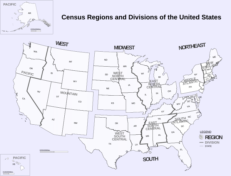
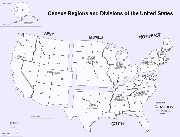
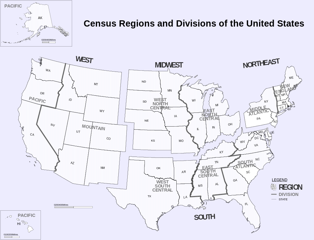
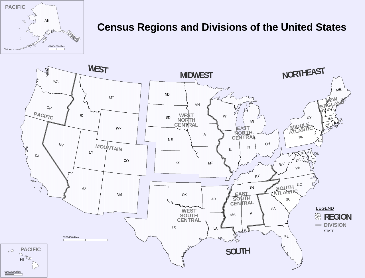
English: Census Regions and Division of the United States. |
| Data | (from pdf) |
| Origine | https://www2.census.gov/geo/pdfs/maps-data/maps/reference/us_regdiv.pdf |
| Autor | US Census Bureau |
| Altere versiones | File:Census Regions and Divisions.PNG |
| SVG genesis |
Licentia
This image or file is a work of a United States Census Bureau employee, taken or made as part of that person's official duties. As a work of the U.S. federal government, the image is in the public domain.
|
 |
Historia del file
Clicca sur un data/hora pro vider le file como appareva a ille tempore.
| Data/Hora | Miniatura | Dimensiones | Usator | Commento | |
|---|---|---|---|---|---|
| actual | 06:02, 6 novembre 2018 | | 942 × 719 (1,27 MB) | JoKalliauer | phab:35245 multiple xkoordinates |
| 23:10, 5 novembre 2018 |  | 942 × 719 (1,27 MB) | JoKalliauer | real text again | |
| 10:53, 26 octobre 2016 |  | 942 × 719 (2,07 MB) | Begoon | fix text | |
| 13:40, 8 maio 2011 |  | 942 × 719 (3,49 MB) | Ras67 | frame and watermark removed | |
| 18:14, 20 junio 2010 |  | 942 × 719 (3,84 MB) | Smallman12q | {{Information |Description={{en|1=Census Regions and Division of the United States. {{Inkscape}}}} |Source=http://www.census.gov/geo/www/us_regdiv.pdf |Author=US Census Bureau |Date=9-7-2000 (from pdf) |Permission={{PD-USGov-DOC-Census}} |other_versions=[ |
Uso de iste file
Le sequente pagina usa iste file:
Uso global de iste file
Le altere wikis sequente usa iste imagine:
- Uso in ar.wikipedia.org
- Uso in ast.wikipedia.org
- Uso in az.wikipedia.org
- Uso in cs.wikipedia.org
- Uso in da.wikipedia.org
- Uso in de.wikipedia.org
- Uso in el.wikipedia.org
- Uso in en.wikipedia.org
- United States Census Bureau
- Mid-Atlantic (United States)
- List of regions of the United States
- Culture of the United States
- Category:Census regions of the United States
- Portal:U.S. roads/Selected picture/Regional balance
- Portal:U.S. roads/Selected article/Regional balance
- Portal:U.S. roads/Did you know/Regional balance
- User:SecretName101/Locations of major party United States presidential nominating conventions
- Uso in eo.wikipedia.org
- Uso in es.wikipedia.org
- Uso in fa.wikipedia.org
- Uso in fr.wikipedia.org
- Uso in he.wikipedia.org
- Uso in hy.wikipedia.org
- Uso in it.wikipedia.org
- Uso in ja.wikipedia.org
- Uso in nl.wikipedia.org
- Uso in pt.wikipedia.org
- Uso in ro.wikipedia.org
- Uso in ru.wikipedia.org
- Uso in ru.wikinews.org
- Uso in sl.wikipedia.org
- Uso in ta.wikipedia.org
- Uso in tr.wikipedia.org
- Uso in ur.wikipedia.org
- Uso in www.wikidata.org