File:Israel relief location map.jpg

Dimension de iste previsualisation: 322 × 598 pixels.Altere resolutiones: 129 × 240 pixels | 614 × 1 141 pixels.
File original (614 × 1 141 pixels, dimension del file: 179 KB, typo MIME: image/jpeg)

|
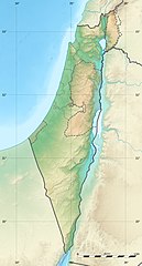
The boundaries on this map show the de facto situation. This is just one of several different views on the subject (see COM:NPOV). |
Summario
| Camera location | | View this and other nearby images on: OpenStreetMap |
|---|
| Description |
Deutsch: Positionskarte von Israel. De-facto-Situation.
Quadratische Plattkarte, N-S-Streckung 115 %. Geographische Begrenzung der Karte: English: Location map of Israel. De facto situation.
Français : Carte physique vierge d'Israël, destinée à la géolocalisation.
Equirectangular projection, N/S stretching 115 %.
Geographic limits of the map:
|
||
| Data | |||
| Origine |
Topographic background map: Own work
|
||
| Autor | Eric Gaba (Sting - fr:Sting) and NordNordWest | ||
| Permission (Reuso de iste file) |
|
||
| Altere versiones |
|
||
| JPG genesis |
|


Licentia
Io, titular del derecto de autor sur iste obra, declara de publicar lo sub le sequente licentias:

|
Le permission es concedite de copiar, distribuer e/o modificar iste documento sub le conditiones del Licentia GNU pro Documentation Libere, Version 1.2 o omne version plus recente publicate per le Fundation pro Software Libere; sin Sectiones Invariabile, sin Textos de Copertura Frontal e sin Textos de Copertura Posterior. Un copia del licentia es includite in le section titulate Licentia GNU pro Documentation Libere. |
Iste file es disponibile sub le licentia Creative Commons Attribution-CompartiSimile 3.0 Non-localisate.
- Tu es libere:
- de condivider – de copiar, distribuer e transmitter le obra
- de remixar – de adaptar le obra
- Sub le sequente conditiones:
- attribution – Tu debe dar information appropriate sur le autor, fornir un ligamine al licentia, e indicar si modificationes ha essite apportate. Tu pote facer lo de qualcunque maniera rationabile, ma non in alcun modo que suggere que le licentiator approba te o tu uso del obra.
- condivider equalmente – Si tu altera, transforma o disveloppa le material, tu debe distribuer tu contributiones sub un licentia identic o compatibile con le original.
Tu pote seliger le licentia de tu preferentia.
Historia del file
Clicca sur un data/hora pro vider le file como appareva a ille tempore.
| Data/Hora | Miniatura | Dimensiones | Usator | Commento | |
|---|---|---|---|---|---|
| actual | 22:49, 3 augusto 2011 | | 614 × 1 141 (179 KB) | Sting | == {{int:filedesc}} == {{Location|31|24|00|N|35|00|00|E|scale:2000000}} {{Information |Description= {{de|Positionskarte von Israel. De-facto-Situation.}} Quadratische Plattkarte, N-S-Streckung 115 %. Geographische Begrenzung der Karte: {{en |
Uso de iste file
Il non ha paginas que usa iste file.
Uso global de iste file
Le altere wikis sequente usa iste imagine:
- Uso in als.wikipedia.org
- Uso in am.wikipedia.org
- Uso in ar.wikipedia.org
- Uso in ary.wikipedia.org
- Uso in arz.wikipedia.org
- Uso in ast.wikipedia.org
- Uso in av.wikipedia.org
- Uso in azb.wikipedia.org
- Uso in az.wikipedia.org
- Uso in ba.wikipedia.org
- Uso in be.wikipedia.org
Vider altere usos global de iste file.