File:KYphysiography.jpg

Dimension de iste previsualisation: 800 × 353 pixels.Altere resolutiones: 320 × 141 pixels | 824 × 364 pixels.
File original (824 × 364 pixels, dimension del file: 159 KB, typo MIME: image/jpeg)

|
This map image could be re-created using vector graphics as an SVG file. This has several advantages; see Commons:Media for cleanup for more information. If an SVG form of this image is available, please upload it and afterwards replace this template with
{{vector version available|new image name}}.
It is recommended to name the SVG file “KYphysiography.svg”—then the template Vector version available (or Vva) does not need the new image name parameter. |


Summario
| Description |
English: I created this image using Wikipedia's map of Kentucky counties.
|
| Data | 1 de maio 2007 (original upload date) |
| Origine | Transferred from en.wikipedia to Commons by byankno1. |
| Autor | Lamontacranston at anglese Wikipedia |
Licentia
| Iste obra ha essite liberate al dominio public per su autor, Lamontacranston at anglese Wikipedia. Isto vale in tote le mundo. In alcun paises isto pote non esser legalmente possibile. In tal caso: Lamontacranston concede a omnes le derecto de usar iste obra pro non importa qual fin, sin conditiones, a minus que tal conditiones sia requirite per lege. |
Registro de incargamento original
The original description page was here. All following user names refer to en.wikipedia.
- 2007-05-01 00:01 Lamontacranston 824×364× (162592 bytes) Bigger fonts. I created this image.
- 2007-04-30 23:54 Lamontacranston 824×364× (154693 bytes) Added text, improved edges, slightly lightened colors. I created the original.
- 2006-09-09 19:16 Lamontacranston 824×364× (55286 bytes) I created this image using Wikipedia's map of Kentucky counties.
Historia del file
Clicca sur un data/hora pro vider le file como appareva a ille tempore.
| Data/Hora | Miniatura | Dimensiones | Usator | Commento | |
|---|---|---|---|---|---|
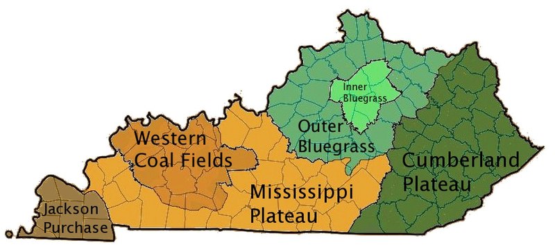
| actual | 16:36, 18 novembre 2008 | | 824 × 364 (159 KB) | EpcotMagic | {{Information |Description={{en|I created this image using Wikipedia's map of Kentucky counties. *Dark green - Eastern Kentucky Coal fields (Cumberland Plateau) *Green - Outer Bluegrass *Light Green - Inner Bluegrass *Light Brown - Mississippi (Pennyroyal |
Uso de iste file
Le sequente pagina usa iste file:
Uso global de iste file
Le altere wikis sequente usa iste imagine:
- Uso in ar.wikipedia.org
- Uso in de.wikipedia.org
- Uso in el.wikipedia.org
- Uso in en.wikipedia.org
- Uso in es.wikipedia.org
- Uso in fi.wikipedia.org
- Uso in he.wikipedia.org
- Uso in id.wikipedia.org
- Uso in it.wikipedia.org
- Uso in ja.wikipedia.org
- Uso in no.wikipedia.org
- Uso in pt.wikipedia.org
- Uso in sh.wikipedia.org
- Uso in simple.wikipedia.org
- Uso in sv.wikipedia.org
- Uso in vi.wikipedia.org
- Uso in zh.wikipedia.org