File:Karte Gazastreifen.png
Dimension de iste previsualisation: 492 × 600 pixels.Altere resolutiones: 197 × 240 pixels | 394 × 480 pixels | 984 × 1 200 pixels.
File original (984 × 1 200 pixels, dimension del file: 347 KB, typo MIME: image/png)

|
This locator map image could be re-created using vector graphics as an SVG file. This has several advantages; see Commons:Media for cleanup for more information. If an SVG form of this image is available, please upload it and afterwards replace this template with
{{vector version available|new image name}}.
It is recommended to name the SVG file “Karte Gazastreifen.svg”—then the template Vector version available (or Vva) does not need the new image name parameter. |
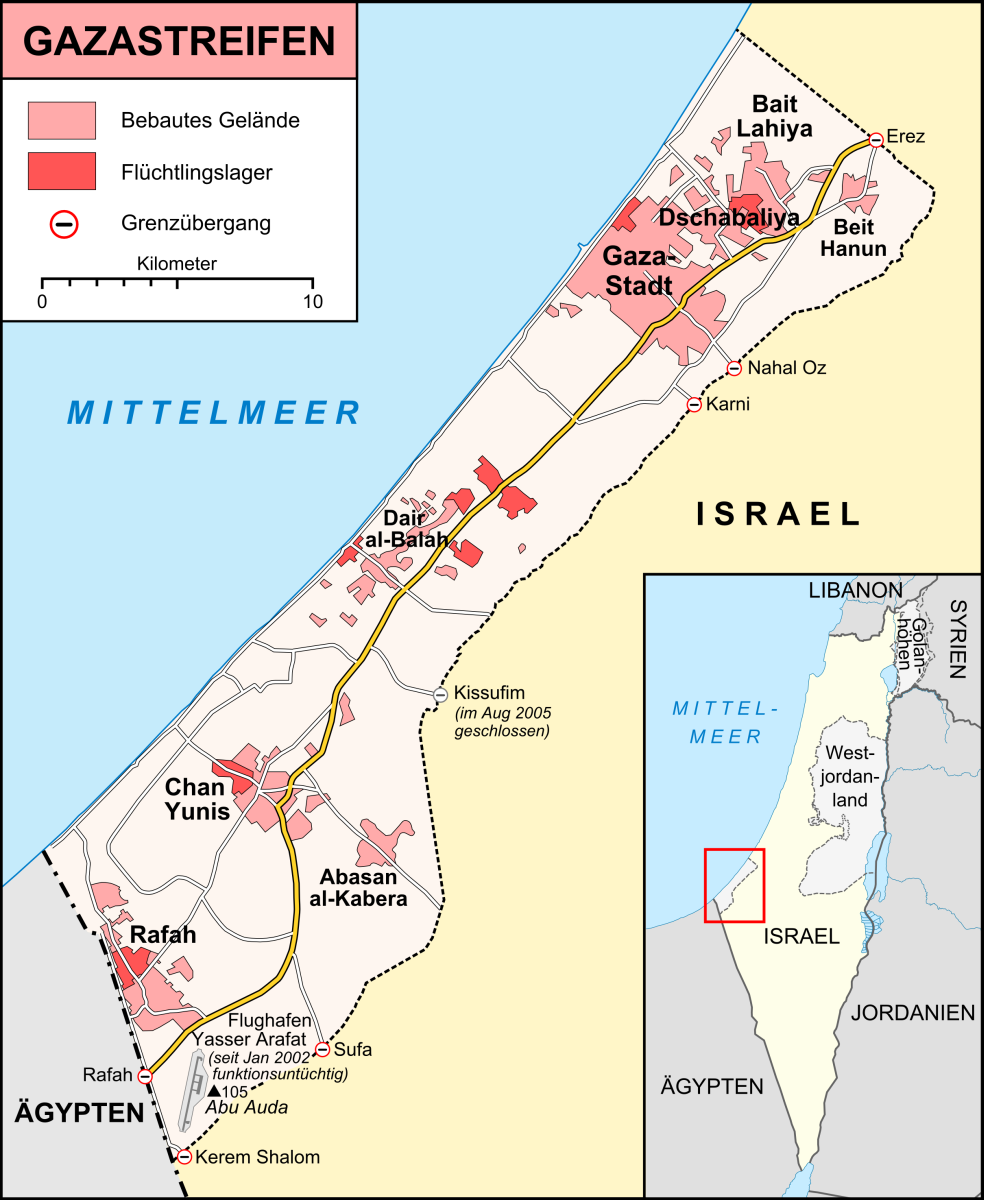
| Description | Karte des Gazastreifens, Stand Dezember 2008 |
| Data | |
| Origine |
own work, used:
|
| Autor | Lencer |
| Altere versiones |
|


Iste file es disponibile sub le licentia Creative Commons Attribution-CompartiSimile 3.0 Non-localisate.
- Tu es libere:
- de condivider – de copiar, distribuer e transmitter le obra
- de remixar – de adaptar le obra
- Sub le sequente conditiones:
- attribution – Tu debe dar information appropriate sur le autor, fornir un ligamine al licentia, e indicar si modificationes ha essite apportate. Tu pote facer lo de qualcunque maniera rationabile, ma non in alcun modo que suggere que le licentiator approba te o tu uso del obra.
- condivider equalmente – Si tu altera, transforma o disveloppa le material, tu debe distribuer tu contributiones sub un licentia identic o compatibile con le original.

|
This map has been made or improved in the German Kartenwerkstatt (Map Lab). You can propose maps to improve as well.
|
Historia del file
Clicca sur un data/hora pro vider le file como appareva a ille tempore.
| Data/Hora | Miniatura | Dimensiones | Usator | Commento | |
|---|---|---|---|---|---|
| actual | 20:42, 6 januario 2009 | | 984 × 1 200 (347 KB) | Lencer | {{Information |Description= |Source= |Date= |Author= |Permission= |other_versions= }} |
| 19:20, 6 januario 2009 |  | 984 × 1 200 (344 KB) | Lencer | {{Information |Description= |Source= |Date= |Author= |Permission= |other_versions= }} | |
| 21:02, 5 januario 2009 |  | 984 × 1 200 (301 KB) | Lencer | {{Information| |Description=Karte des Gazastreifens, Stand Dezember 2008 |Source=own work, used: * [http://unosat.web.cern.ch/unosat/asp/prod_free.asp?pid=1304 UNOSAT, Situation Map-Gaza Crisis] * [http://www.spiegel.de/politik/auslan | |
| 20:34, 5 januario 2009 |  | 984 × 1 200 (279 KB) | Lencer | {{Information| |Description=Karte des Gazastreifens, Stand Dezember 2008 |Source=own work, used: * [http://unosat.web.cern.ch/unosat/asp/prod_free.asp?pid=1304 UNOSAT, Situation Map-Gaza Crisis] * [http://www.spiegel.de/politik/auslan |
Uso de iste file
Le sequente pagina usa iste file:
Uso global de iste file
Le altere wikis sequente usa iste imagine:
- Uso in arz.wikipedia.org
- Uso in bg.wikipedia.org
- Uso in de.wikipedia.org
- Operation Sommerregen
- Benutzer:Lencer
- Kampf um Gaza im Juni 2007
- Grenzübergang Karni
- Dezember 2008
- Operation Gegossenes Blei
- Wikipedia:Kartenwerkstatt/Archiv/2009-01
- Goldstone-Bericht
- Benutzer:Uwe Dedering/Länderliste
- Operation Wolkensäule
- Tunnelsystem im Gazastreifen
- Wikipedia:Kartenwerkstatt/Archiv/2013-10
- Operation Protective Edge
- Wikipedia:Kartenwerkstatt/Karte des Tages/Galerie
- Benutzer:Eandré/Studien/Nahost
- Glossar zu Kulturdenkmälern im Gazastreifen
- Uso in de.wikinews.org
- Uso in de.wikivoyage.org
- Uso in eo.wikipedia.org
- Uso in fa.wikipedia.org
- Uso in fi.wikipedia.org
- Uso in frr.wikipedia.org
- Uso in nl.wikipedia.org
- Uso in pl.wiktionary.org
- Uso in www.wikidata.org