File:Karte Innsbruck - Katastralgemeinden und Statistische Stadtteile.png
Dimension de iste previsualisation: 435 × 599 pixels.Altere resolutiones: 174 × 240 pixels | 349 × 480 pixels | 558 × 768 pixels | 1 188 × 1 635 pixels.
File original (1 188 × 1 635 pixels, dimension del file: 435 KB, typo MIME: image/png)
Summario
| Description |
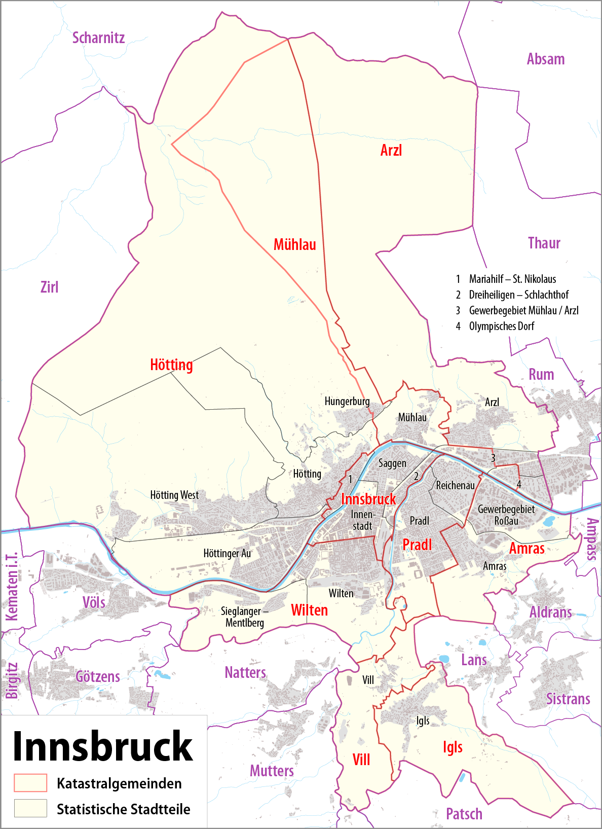
Deutsch: Karte von Innsbruck: Katastralgemeinden und statistische Stadtteile
English: Map of Innsbruck: cadastral communities and statistical districts |
|||
| Data | see file history | |||
| Origine |
Obra proprie, using
|
|||
| Autor | Maximilian Dörrbecker (Chumwa) | |||
| Permission (Reuso de iste file) |
Iste file es disponibile sub le licentia Creative Commons Attribution-CompartiSimile 2.0 Generic.
Sie dürfen das Bild zu den folgenden Bedingungen nutzen:
|
|||
| Altere versiones |
Statistical districs of Innsbruck
Cadastral communities of Innsbruck
|


Historia del file
Clicca sur un data/hora pro vider le file como appareva a ille tempore.
| Data/Hora | Miniatura | Dimensiones | Usator | Commento | |
|---|---|---|---|---|---|
| actual | 22:20, 7 junio 2015 | | 1 188 × 1 635 (435 KB) | Cmdrjameson | Compressed with pngout. Reduced by 254kB (36% decrease). |
| 20:33, 3 septembre 2014 |  | 1 188 × 1 635 (690 KB) | Chumwa | ||
| 19:11, 8 augusto 2014 |  | 1 188 × 1 635 (689 KB) | Chumwa | ||
| 23:17, 7 augusto 2014 |  | 1 188 × 1 635 (634 KB) | Chumwa | ||
| 22:38, 7 augusto 2014 |  | 1 188 × 1 635 (633 KB) | Chumwa | == {{int:filedesc}} == {{Information |Description = {{de|1=Karte von Innsbruck: Katastralgemeinden und Statistische Stadtteile}} {{en|1=Map of Innsbruck: cadastral communities and statistic districts}} |Source={{own}}, using OpenStreetMap data f... |
Uso de iste file
Il non ha paginas que usa iste file.
Uso global de iste file
Le altere wikis sequente usa iste imagine:
- Uso in ca.wikipedia.org
- Uso in de.wikipedia.org
- Uso in en.wikipedia.org
- Uso in et.wikipedia.org
- Uso in ga.wikipedia.org
- Uso in gl.wikipedia.org
- Uso in hy.wikipedia.org
- Uso in incubator.wikimedia.org
- Uso in lld.wikipedia.org
- Uso in vep.wikipedia.org
- Uso in vi.wikipedia.org
- Uso in www.wikidata.org