File:Kingdom of Numidia-02.png

Dimension de iste previsualisation: 800 × 346 pixels.Altere resolutiones: 320 × 138 pixels | 640 × 277 pixels | 1 024 × 443 pixels | 2 246 × 971 pixels.
File original (2 246 × 971 pixels, dimension del file: 495 KB, typo MIME: image/png)
Summario
| Description |
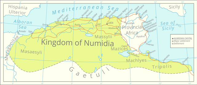
English: This map was assembled using the boundaries of this map, Roman road data from this [1] dataset, river and lake data from the Pergamon Atlas as well as settlement significance from the Barrington Atlas.
The graphics were assembled in QGIS and processed in Adobe Illustrator. All data is projected in the Lambert azimuthal equal-area projection. |
| Data | |
| Origine | Obra proprie |
| Autor | Cattette |
Licentia
Io, titular del derecto de autor sur iste obra, declara de publicar lo sub le sequente licentia:
Iste file es disponibile sub le licentia Creative Commons Attribution 4.0 International.
- Tu es libere:
- de condivider – de copiar, distribuer e transmitter le obra
- de remixar – de adaptar le obra
- Sub le sequente conditiones:
- attribution – Tu debe dar information appropriate sur le autor, fornir un ligamine al licentia, e indicar si modificationes ha essite apportate. Tu pote facer lo de qualcunque maniera rationabile, ma non in alcun modo que suggere que le licentiator approba te o tu uso del obra.
Historia del file
Clicca sur un data/hora pro vider le file como appareva a ille tempore.
| Data/Hora | Miniatura | Dimensiones | Usator | Commento | |
|---|---|---|---|---|---|
| actual | 00:26, 30 martio 2021 | | 2 246 × 971 (495 KB) | Cattette | Uploaded own work with UploadWizard |
Uso de iste file
Le sequente pagina usa iste file:
Uso global de iste file
Le altere wikis sequente usa iste imagine:
- Uso in ar.wikipedia.org
- Uso in ast.wikipedia.org
- Uso in az.wikipedia.org
- Uso in bs.wikipedia.org
- Uso in ca.wikipedia.org
- Uso in cs.wikipedia.org
- Uso in de.wikipedia.org
- Uso in el.wikipedia.org
- Uso in en.wikipedia.org
- Uso in eo.wikipedia.org
- Uso in fa.wikipedia.org
- Uso in fi.wikipedia.org
- Uso in fr.wikipedia.org
- Uso in fy.wikipedia.org
- Uso in gl.wikipedia.org
- Uso in ha.wikipedia.org
- Uso in ja.wikipedia.org
- Uso in kab.wikipedia.org
- Uso in ko.wikipedia.org
- Uso in lt.wikipedia.org
- Uso in lv.wikipedia.org
- Uso in mk.wikipedia.org
- Uso in pl.wikipedia.org
- Uso in rue.wikipedia.org
- Uso in sl.wikipedia.org
- Uso in www.wikidata.org