File:Map-balkans-vlachs.png
Non disponibile in resolution plus alte.
Map-balkans-vlachs.png (440 × 337 pixels, dimension del file: 71 KB, typo MIME: image/png)

|
This linguistic map image could be re-created using vector graphics as an SVG file. This has several advantages; see Commons:Media for cleanup for more information. If an SVG form of this image is available, please upload it and afterwards replace this template with
{{vector version available|new image name}}.
It is recommended to name the SVG file “Map-balkans-vlachs.svg”—then the template Vector version available (or Vva) does not need the new image name parameter. |
Summario
| Description |
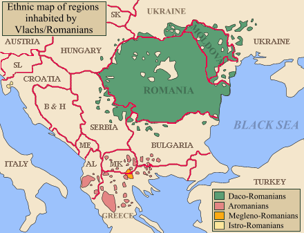
Aragonés: Rechions con important población vlaca.
ܐܪܡܝܐ : ܦܢܝܬ̈ܐ ܕܒܗܘܢ ܢܬܡܠܠ ܠܫܢܐ ܪܘܡܢܝܐ.
العربية: Regions with green inhabited by significant Romanian population.
Български: Областите обозначени със зелено са население предимно с румънско население,с червено арумънско население а с жълто мъгленорумъни.
Bosanski: Područja označena zelenom naseljena značajnijom rumunskom populacijom.
Català: Mapa ètnic del romanès. Mapa dels Balcans amb les regions habitades per aromanesos en vermell.
Čeština: Mapa rozšíření Rumunštiny a jejích dialektů po Balkánu. Mapa balkánu, Arumuni zobrazeni červeně.
Dansk: Etnisk oversigtskort.
Deutsch: Die Dialekte des rumänischen Sprachareals im weitesten Sinn des Begriffes. Das Verbreitungsareal der vier walachischen (rumänischen) Sprachen der balkanromanischen Sprachgruppe. Das Verbreitungsgebiet der 4 balkanromanischen Sprachen. Das Verbreitungsgebiet der 4 Balkanromanischen (Walachischen) Sprachen. In den Gebieten außerhalb Rumäniens und Moldawiens ist oft die romanischsprachige Bevölkerung weniger zahlreich als die nichtromanische Mehrheitsbevölkerung. Verbreitung der Rumänen im weiteren Sinn des Begriffes (Walachen). Das istrorumänische Areal ist in einer hellen gelben Farbe dargestellt. Balkanromanische Sprachen rumänischer Zugehörigkeit im Sinne von 2., historischer Stand; die Gebiete außerhalb Rumäniens/Moldawiens zeigen nicht unbedingt an, dass in ihnen die Mehrheit der Bevölkerung rumänisch spricht/sprach. Das Verbreitungsgebiet der vier balkanromanischen (walachischen) Sprachen. In den Gebieten außerhalb Rumäniens und Moldawiens bildet die romanischsprachige Bevölkerung meistens eine Minderheit. Balkanromanische Sprachen im Sinne von a) 1. (Rumänische Idiome). Das Dakorumänische Sprachareal ist grün eingetragen; die Gebiete außerhalb Rumäniens/Moldawiens zeigen nicht unbedingt an, dass in ihnen die Mehrheit der Bevölkerung rumänisch spricht.
Ελληνικά: Η γεωγραφική εξάπλωση της Βλάχικης γλώσσας (με ροζ), καθώς και της βλάχικης διαλέκτου των Μογλενών (με πορτοκαλί) στην Μακεδονία, την Ήπειρο, την Αλβανία και την Π.Γ.Δ.Μ. Χάρτης των Βαλκανίων με τονισμένες τις περιοχές που κατοικούνται από Λατινόφωνους.
English: Map of the Balkans with regions inhabited by Romanians/Vlachs (Eastern Romance speakers) highlighted. Please note that not in all the regions highlighted, Romanian language is used by the majority of speakers. In some regions it only notes presence of a minority Romanian-speaking community. Regions inhabited by Daco-Romanian speakers in green, Aromanians in red, Megleno-Romanians in yellow, Istro-Romanians in pink (far west in modern day Croatia). |
| Origine | Self-published work by Olahus |
| Autor | Olahus |
| Altere versiones | Evolution of the Eastern Romance languages and of the Wallachian territories from 6th century to the 16th century AD.jpg |

|
This image (or all images in this category) uses inside labels or attached captions in a specific script or language and should be converted to a language neutral form. This would allow its use in all Wikimedia projects and, more importantly, all Wikimedia languages.
|
Licentia
Io, titular del derecto de autor sur iste obra, declara de publicar lo sub le sequente licentias:

|
Le permission es concedite de copiar, distribuer e/o modificar iste documento sub le conditiones del Licentia GNU pro Documentation Libere, Version 1.2 o omne version plus recente publicate per le Fundation pro Software Libere; sin Sectiones Invariabile, sin Textos de Copertura Frontal e sin Textos de Copertura Posterior. Un copia del licentia es includite in le section titulate Licentia GNU pro Documentation Libere. |
| Iste file es disponibile sub le licentia Creative Commons Attribution-CompartiSimile 3.0 Non-localisate. | ||
| ||
| Iste etiquetta de licentia esseva addite a iste file como parte del actualisation del licentia GFDL. |
Tu pote seliger le licentia de tu preferentia.
Historia del file
Clicca sur un data/hora pro vider le file como appareva a ille tempore.
| Data/Hora | Miniatura | Dimensiones | Usator | Commento | |
|---|---|---|---|---|---|
| actual | 22:17, 2 decembre 2022 | | 440 × 337 (71 KB) | Sadko | Reverted to version as of 13:55, 26 February 2022 (UTC) There was no such territory at the beggining of the 20th century. Borders* should be presented neutrally. |
| 13:27, 2 martio 2022 |  | 440 × 337 (26 KB) | InNeed95 | Reverted to version as of 06:57, 24 February 2022 (UTC)RV repeating Vandalism | |
| 13:55, 26 februario 2022 |  | 440 × 337 (71 KB) | TómasdeAquino2 | rv vandalism | |
| 06:57, 24 februario 2022 |  | 440 × 337 (26 KB) | Ahmet Q. | Reverted to version as of 15:55, 15 August 2019 (UTC)rv vandalism | |
| 01:49, 16 novembre 2021 |  | 440 × 337 (71 KB) | TómasdeAquino2 | minor fix | |
| 15:55, 15 augusto 2019 |  | 440 × 337 (26 KB) | Julieta39 | Correct ISO codes | |
| 08:52, 24 april 2019 |  | 440 × 337 (26 KB) | Julieta39 | Borders, countries | |
| 14:00, 1 novembre 2008 |  | 440 × 337 (22 KB) | Olahus | {{Information |Description= |Source= |Date= |Author= |Permission= |other_versions= }} | |
| 19:47, 23 septembre 2008 |  | 440 × 337 (22 KB) | Skatefreak | Reverted to version as of 19:46, 23 September 2008 | |
| 19:47, 23 septembre 2008 |  | 440 × 337 (22 KB) | Skatefreak | {{Information |Description= |Source= |Date= |Author= |Permission= |other_versions= }} |
Uso de iste file
Le sequente pagina usa iste file:
Uso global de iste file
Le altere wikis sequente usa iste imagine:
- Uso in af.wikipedia.org
- Uso in am.wikipedia.org
- Uso in an.wikipedia.org
- Uso in arc.wikipedia.org
- Uso in ar.wikipedia.org
- Uso in arz.wikipedia.org
- Uso in ba.wikipedia.org
- Uso in bg.wikipedia.org
- Uso in br.wikipedia.org
- Uso in bs.wikipedia.org
- Uso in ca.wikipedia.org
- Uso in ce.wikipedia.org
- Uso in cs.wikipedia.org
- Uso in cv.wikipedia.org
- Uso in da.wikipedia.org
- Uso in de.wikipedia.org
- Uso in dsb.wikipedia.org
- Uso in el.wikipedia.org
Vider altere usos global de iste file.