File:Map of Tokyo Ja.svg

File original (File SVG, dimensiones nominal: 847 × 635 pixels, grandor del file: 74 KB)
Summario
| Description |
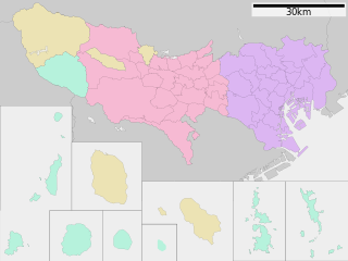
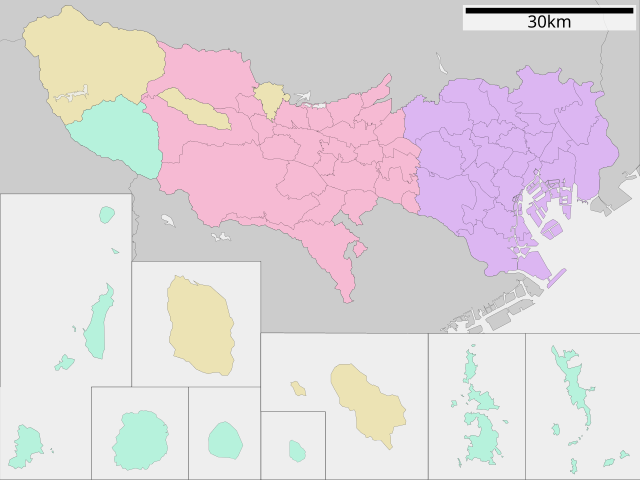
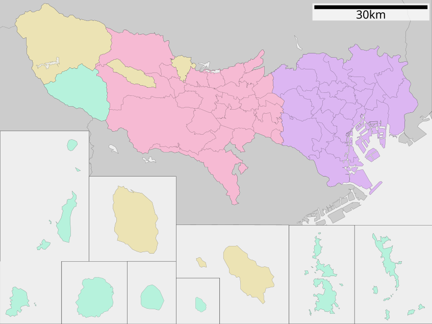
English: Map of Tokyo Prefecture, Japan.
日本語: ja:東京都区画図 |
||
| Data | (UTC) | ||
| Origine |
|
||
| Autor | Lincun | ||
| Permission (Reuso de iste file) |
|
Licentia

|
Le permission es concedite de copiar, distribuer e/o modificar iste documento sub le conditiones del Licentia GNU pro Documentation Libere, Version 1.2 o omne version plus recente publicate per le Fundation pro Software Libere; sin Sectiones Invariabile, sin Textos de Copertura Frontal e sin Textos de Copertura Posterior. Un copia del licentia es includite in le section titulate Licentia GNU pro Documentation Libere. |
- Tu es libere:
- de condivider – de copiar, distribuer e transmitter le obra
- de remixar – de adaptar le obra
- Sub le sequente conditiones:
- attribution – Tu debe dar information appropriate sur le autor, fornir un ligamine al licentia, e indicar si modificationes ha essite apportate. Tu pote facer lo de qualcunque maniera rationabile, ma non in alcun modo que suggere que le licentiator approba te o tu uso del obra.
- condivider equalmente – Si tu altera, transforma o disveloppa le material, tu debe distribuer tu contributiones sub un licentia identic o compatibile con le original.
Registro de incargamento original
| This file was moved from Japanese Wikipedia.
See below for original file information. | ||||||||||||||||||||||||||||||||||||||||||||||||||||||||||||||||||||||||
| ||||||||||||||||||||||||||||||||||||||||||||||||||||||||||||||||||||||||
|
| ||||||||||||||||||||||||||||||||||||||||||||||||||||||||||||||||||||||||
Historia del file
Clicca sur un data/hora pro vider le file como appareva a ille tempore.
| Data/Hora | Miniatura | Dimensiones | Usator | Commento | |
|---|---|---|---|---|---|
| actual | 11:32, 12 februario 2023 | | 847 × 635 (74 KB) | Maanshen | Fixed border |
| 02:31, 18 januario 2023 |  | 847 × 635 (74 KB) | Maanshen | Minor changes to borders and boxes are now thinner | |
| 02:04, 18 januario 2023 |  | 847 × 635 (74 KB) | Maanshen | Fixed ocean color | |
| 02:03, 18 januario 2023 |  | 847 × 635 (74 KB) | Maanshen | Changes with the outline color for boxes onto black and completely revamped borders | |
| 04:53, 23 augusto 2019 |  | 800 × 610 (34 KB) | LT sfm | Changed the line weight | |
| 04:48, 23 augusto 2019 |  | 800 × 610 (34 KB) | LT sfm | 線の太さ修正 | |
| 04:06, 23 augusto 2019 |  | 800 × 610 (34 KB) | LT sfm | Fixed the color of Hahajima Islands(town to village) | |
| 03:59, 23 augusto 2019 |  | 800 × 610 (34 KB) | LT sfm | 母島列島(小笠原村)が町の配色になっていたのを修正 | |
| 07:42, 9 junio 2013 |  | 800 × 610 (45 KB) | ニンジンシチュー | デザイン変更(スケールバーの位置、配色) | |
| 07:41, 9 junio 2013 |  | 800 × 610 (45 KB) | ニンジンシチュー | デザイン変更(スケールバーの位置、配色) |
Uso de iste file
Il non ha paginas que usa iste file.
Uso global de iste file
Le altere wikis sequente usa iste imagine:
- Uso in et.wikipedia.org
- Uso in fa.wikipedia.org
- Uso in fi.wikipedia.org
- Uso in fr.wikipedia.org
- Uso in fr.wiktionary.org
- Uso in it.wikipedia.org
- Tokyo
- Shinjuku
- Quartieri speciali di Tokyo
- Musashino
- Mitaka
- Hachiōji
- Minato
- Shibuya
- Inagi
- Adachi (Tokyo)
- Taitō
- Setagaya
- Chiyoda (Tokyo)
- Meguro
- Shinagawa
- Template:Tokyo
- Akiruno
- Akishima
- Chōfu
- Fuchū (Tokyo)
- Hamura
- Higashikurume
- Higashimurayama
- Higashiyamato
- Hino
- Kiyose
- Kodaira
- Koganei
- Kokubunji
- Komae
- Kunitachi
- Machida
- Musashimurayama
- Nishi-Tokyo
- Ōme
- Tachikawa
- Tama (Tokyo)
- Suginami
- Nerima
- Ōta (Tokyo)
- Bunkyō
- Edogawa
- Chūō (Tokyo)
- Kita (Tokyo)
- Kōtō
Vider altere usos global de iste file.