File:New 2000 hispanic density.gif

Dimension de iste previsualisation: 776 × 600 pixels.Altere resolutiones: 311 × 240 pixels | 621 × 480 pixels | 994 × 768 pixels | 1 280 × 989 pixels | 2 604 × 2 012 pixels.
File original (2 604 × 2 012 pixels, dimension del file: 619 KB, typo MIME: image/gif)

|
This ethnographic map image could be re-created using vector graphics as an SVG file. This has several advantages; see Commons:Media for cleanup for more information. If an SVG form of this image is available, please upload it and afterwards replace this template with
{{vector version available|new image name}}.
It is recommended to name the SVG file “New 2000 hispanic density.svg”—then the template Vector version available (or Vva) does not need the new image name parameter. |
Summario
| Description |
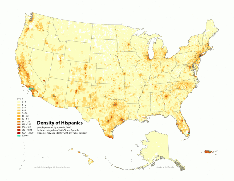
English: Map of contiguous US, showing density of self-reported "Hispanic" population, in persons per square mile, by census tract, 2000. Data source: US Census. |
| Data | 3 de april 2006 (original upload date) |
| Origine | Obra proprie |
| Autor |
similar maps:
- Image:New 2000 asian density.gif
- Image:New 2000 asian percent.gif
- Image:New 2000 black density.gif
- Image:New 2000 black percent.gif
- Image:New 2000 hawaiian density.gif
- Image:New 2000 hawaiian percent.gif
- Image:New 2000 hispanic density.gif
- Image:New 2000 hispanic percent.gif
- Image:New 2000 indian density.gif
- Image:New 2000 indian percent.gif
- Image:New 2000 white density.gif
- Image:New 2000 white percent.gif
Licentia
Iste file es disponibile sub le licentia Creative Commons Attribution-CompartiSimile 2.5 Generic.
- Tu es libere:
- de condivider – de copiar, distribuer e transmitter le obra
- de remixar – de adaptar le obra
- Sub le sequente conditiones:
- attribution – Tu debe dar information appropriate sur le autor, fornir un ligamine al licentia, e indicar si modificationes ha essite apportate. Tu pote facer lo de qualcunque maniera rationabile, ma non in alcun modo que suggere que le licentiator approba te o tu uso del obra.
- condivider equalmente – Si tu altera, transforma o disveloppa le material, tu debe distribuer tu contributiones sub un licentia identic o compatibile con le original.
Registro de incargamento original
Transferred from en.wikipedia to Commons using For the Common Good.
The original description page was here. All following user names refer to en.wikipedia.
| Data/Hora | Dimensiones | Usator | Commento |
|---|---|---|---|
| 19:16, 1 May 2010 | 2,604 × 2,012 (633,459 bytes) | w:en:Citynoise (discussion | contributiones) | (Added Alaska, Hawaii, and Territories. Also changed from tracts to zip codes.) |
| 02:07, 3 April 2006 | 1,012 × 691 (98,873 bytes) | w:en:Citynoise (discussion | contributiones) | (Map of contiguous US, showing density of self-reported "Hispanic" population, in persons per square mile, by census tract, 2000. Data source: US Census. I am the designer and creator of this map and license it under the Creative Commons Attribution Sh) |
Historia del file
Clicca sur un data/hora pro vider le file como appareva a ille tempore.
| Data/Hora | Miniatura | Dimensiones | Usator | Commento | |
|---|---|---|---|---|---|
| actual | 18:43, 10 februario 2013 | | 2 604 × 2 012 (619 KB) | Fredlyfish4 | Transferred from en.wikipedia: see original upload log above |
Uso de iste file
Le sequente pagina usa iste file:
Uso global de iste file
Le altere wikis sequente usa iste imagine:
- Uso in de.wikiversity.org
- Uso in en.wikipedia.org
- Uso in fa.wikipedia.org
- Uso in tl.wikipedia.org