File:Possible definitions of the boundary between Europe and Asia.png
Dimension de iste previsualisation: 387 × 599 pixels.Altere resolutiones: 155 × 240 pixels | 310 × 480 pixels | 729 × 1 129 pixels.
File original (729 × 1 129 pixels, dimension del file: 207 KB, typo MIME: image/png)
Summario
| Description |
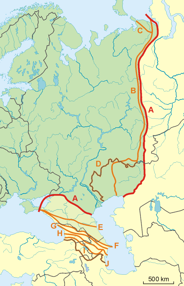
English: A map of possible definitions of the boundary between Asia and Europe.
Note that most of these lines are not referenced to any sources proposing them. The red line marked "A" is apparently the "Strahlenberg" definition commononly taught in Soviet-era Russia. See File:Historical Europe-Asia boundaries 1700 to 1900.png for a map which is actually based on references. The modern mainstream definition used by the UN (see also this) are marked "B" (Urals and Ural River) and "F" (Caucasus watershed). Lines C, D, E, G, H, I and J are currently without reference. Red line - "Strahlenberg" border, allegedly also used by the International Geographical Union [1]
Orange lines - other variants of border:
Polski: Mapa wariantów przebiegów granicy pomiędzy Europą a Azją
linie pomarańczowe - inne warianty przebiegu granicy:
|
| Data | 09-04-2008 |
| Origine | Obra proprie |
| Autor | Aotearoa |
| Altere versiones | Image:TransAsia m.png, File:Historical Europe-Asia boundaries 1700 to 1900.png |
Licentia

|
Le permission es concedite de copiar, distribuer e/o modificar iste documento sub le conditiones del Licentia GNU pro Documentation Libere, Version 1.2 o omne version plus recente publicate per le Fundation pro Software Libere; sin Sectiones Invariabile, sin Textos de Copertura Frontal e sin Textos de Copertura Posterior. Un copia del licentia es includite in le section titulate Licentia GNU pro Documentation Libere. |
- Tu es libere:
- de condivider – de copiar, distribuer e transmitter le obra
- de remixar – de adaptar le obra
- Sub le sequente conditiones:
- attribution – Tu debe dar information appropriate sur le autor, fornir un ligamine al licentia, e indicar si modificationes ha essite apportate. Tu pote facer lo de qualcunque maniera rationabile, ma non in alcun modo que suggere que le licentiator approba te o tu uso del obra.
- condivider equalmente – Si tu altera, transforma o disveloppa le material, tu debe distribuer tu contributiones sub un licentia identic o compatibile con le original.
Historia del file
Clicca sur un data/hora pro vider le file como appareva a ille tempore.
| Data/Hora | Miniatura | Dimensiones | Usator | Commento | |
|---|---|---|---|---|---|
| actual | 08:34, 14 novembre 2022 | | 729 × 1 129 (207 KB) | Рагин1987 | Dull shade of green up to the "F" line |
| 13:12, 19 februario 2022 |  | 729 × 1 129 (205 KB) | Lojwe | Frame removed | |
| 20:29, 1 octobre 2010 |  | 735 × 1 134 (156 KB) | Bogomolov.PL | Reverted to version as of 08:57, 9 April 2008 | |
| 19:44, 1 octobre 2010 |  | 735 × 1 134 (137 KB) | Zé Carioca~commonswiki | Trying to fix the error we are facing on the articles. | |
| 15:56, 1 octobre 2010 |  | 735 × 1 134 (137 KB) | Gvogas | Inclusion of the Miles Clark route line. (sorry for the tries, my internet gave problems). | |
| 15:55, 1 octobre 2010 |  | 735 × 1 134 (137 KB) | Gvogas | Reverted to version as of 15:52, 1 October 2010 | |
| 15:54, 1 octobre 2010 |  | 735 × 1 134 (137 KB) | Gvogas | (Inclusion of the Miles Clark route line.) | |
| 15:52, 1 octobre 2010 |  | 735 × 1 134 (137 KB) | Gvogas | Inclusion of the Miles Clark route line. | |
| 08:57, 9 april 2008 |  | 735 × 1 134 (156 KB) | Aotearoa | {{Information |Description=Map of Europe (green) - Asia (yellow) border. Red line (A) - border accoring to International Geographical Union and most European geographers, orange lines - other variants of border. |Source=własna praca |Date=09-04-2008 | |
Uso de iste file
Le sequente 2 paginas usa iste file:
Uso global de iste file
Le altere wikis sequente usa iste imagine:
- Uso in am.wikipedia.org
- Uso in ar.wikipedia.org
- Uso in arz.wikipedia.org
- Uso in az.wikipedia.org
- Uso in ba.wikipedia.org
- Uso in be.wikipedia.org
- Uso in bn.wikipedia.org
- Uso in ca.wikipedia.org
- Uso in ce.wikipedia.org
- Uso in cs.wikipedia.org
- Uso in de.wikipedia.org
- Eurasien
- Portal:Mauern und Grenzen
- Liste interkontinentaler Staaten
- Wikipedia Diskussion:WikiProjekt Geographie/Archiv/2013-1
- Wikipedia:Löschkandidaten/28. Februar 2016
- Wikipedia Diskussion:WikiProjekt Kategorien/Archiv/2016-II
- Wikipedia Diskussion:Kurier/Archiv/2017/10
- Vorlage Diskussion:Navigationsleiste Kraftwerke
- Wikipedia Diskussion:Kurier/Archiv/2022/08
- Uso in en.wikipedia.org
- Uso in et.wikipedia.org
- Uso in hr.wikipedia.org
- Kategorija:Arktičkooceanski slijev (Europa)
- Kategorija:Arktičkooceanski slijev (Azija)
- Kategorija:Mora Arktičkog oceana
- Kategorija:Reljefni oblici u Arktičkom oceanu
- Kategorija:Mora Arktičkog oceana (Azija)
- Kategorija:Mora Arktičkog oceana (Europa)
- Kategorija:Reljefni oblici u Arktičkom oceanu (Azija)
- Kategorija:Tjesnaci Arktičkog oceana (Europa)
- Kategorija:Vodene mase Arktičkog oceana (Europa)
- Kategorija:Reljefni oblici u Arktičkom oceanu (Europa)
- Kategorija:Tjesnaci Arktičkog oceana (Azija)
- Kategorija:Vodene mase Arktičkog oceana (Azija)
- Kategorija:Karsko more
- Predložak:Granica Europe i Azije
- Kategorija:Zaljevi Arktičkog oceana (Azija)
- Kategorija:Zaljevi Arktičkog oceana (Europa)
- Kategorija:Estuariji Arktičkog oceana (Azija)
- Kategorija:Estuariji Tihog oceana (Azija)
- Uso in hu.wikipedia.org
- Uso in hy.wikipedia.org
Vider altere usos global de iste file.