File:Ragusa.png
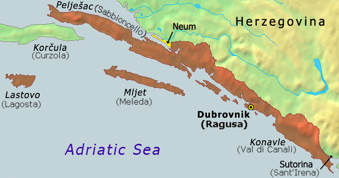
Ragusa.png (675 × 354 pixels, dimension del file: 128 KB, typo MIME: image/png)
Historia del file
Clicca sur un data/hora pro vider le file como appareva a ille tempore.
| Data/Hora | Miniatura | Dimensiones | Usator | Commento | |
|---|---|---|---|---|---|
| actual | 07:51, 21 octobre 2020 |  | 675 × 354 (128 KB) | Claude Zygiel | Ragusan / Venetian names also (official until 1918) |
| 19:49, 6 februario 2020 |  | 675 × 354 (114 KB) | Ceha | Klek was part of Dubrovnik Republic. Tip of the peninsula is in Croatia, while the rest is in BiH. The same goes for the small island of Lastavica, which is today in Montenegro... https://www.google.com/maps/place/Mamula/@42.3952695,18.4181714,11z/data=!4m5!3m4!1s0x134c24e629d0b6ed:0x1d78b87fc20846b1!8m2!3d42.3954043!4d18.5585609 | |
| 21:15, 8 septembre 2010 |  | 675 × 354 (65 KB) | DIREKTOR | fix | |
| 17:02, 25 novembre 2006 |  | 675 × 354 (53 KB) | Tieum512 | {{Information |Description=Map of the Republic of Ragusa as of 1808 Based on Demis Web Map Server output |Source=http://en.wikipedia.org/wiki/Image:Ragusa.png |Date= |Author=User:ChrisO |Permission=GFDL |other_versions= }} |
Uso de iste file
Le sequente pagina usa iste file:
Uso global de iste file
Le altere wikis sequente usa iste imagine:
- Uso in an.wikipedia.org
- Uso in ar.wikipedia.org
- Uso in ast.wikipedia.org
- Uso in azb.wikipedia.org
- Uso in az.wikipedia.org
- Uso in be-tarask.wikipedia.org
- Uso in be.wikipedia.org
- Uso in bg.wikipedia.org
- Uso in br.wikipedia.org
- Uso in bs.wikipedia.org
- Uso in ca.wikipedia.org
- Uso in cs.wikipedia.org
- Uso in da.wikipedia.org
- Uso in de.wikipedia.org
- Uso in el.wikipedia.org
- Uso in en.wikipedia.org
- Uso in eo.wikipedia.org
- Uso in es.wikipedia.org
- Uso in et.wikipedia.org
- Uso in eu.wikipedia.org
- Uso in fa.wikipedia.org
- Uso in fi.wikipedia.org
- Uso in fr.wikipedia.org
- Uso in fy.wikipedia.org
- Uso in gl.wikipedia.org
- Uso in he.wikipedia.org
- Uso in hu.wikipedia.org
- Uso in id.wikipedia.org
- Uso in ie.wikipedia.org
- Uso in it.wikipedia.org
- Uso in ja.wikipedia.org
- Uso in ko.wikipedia.org
- Uso in li.wikipedia.org
- Uso in mk.wikipedia.org
- Uso in ms.wikipedia.org
- Uso in mt.wikipedia.org
Vider altere usos global de iste file.


