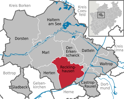
File:Recklinghausen in RE.svg

Dimension de iste previsualisation PNG de iste file SVG: 423 × 340 pixels. Altere resolutiones: 299 × 240 pixels | 597 × 480 pixels | 956 × 768 pixels | 1 274 × 1 024 pixels | 2 548 × 2 048 pixels.
File original (File SVG, dimensiones nominal: 423 × 340 pixels, grandor del file: 1,39 MB)
Historia del file
Clicca sur un data/hora pro vider le file como appareva a ille tempore.
| Data/Hora | Miniatura | Dimensiones | Usator | Commento | |
|---|---|---|---|---|---|
| actual | 17:34, 31 maio 2013 |  | 423 × 340 (1,39 MB) | TUBS | |
| 22:18, 26 novembre 2010 |  | 423 × 340 (288 KB) | Hagar66 | {{Information |Description= |Source= |Date= |Author= |Permission= |other_versions= }} | |
| 13:03, 14 decembre 2009 |  | 509 × 385 (856 KB) | Hagar66 | {{Information |Description= |Source= |Date= |Author= |Permission= |other_versions= }} | |
| 14:45, 26 augusto 2008 |  | 509 × 385 (1,28 MB) | TUBS | == Summary == {{Information |Description=Recklinghausen in Kreis Recklinghausen, Nordrhein-Westfalen |Source=<imagemap> image:North rhine w template 2.png|100px| default Image:North rhine w template 2.svg desc none </imagemap> |Date=2008 |Author=[[Us |
Uso de iste file
Le sequente pagina usa iste file:
Uso global de iste file
Le altere wikis sequente usa iste imagine:
- Uso in ar.wikipedia.org
- Uso in arz.wikipedia.org
- Uso in ast.wikipedia.org
- Uso in azb.wikipedia.org
- Uso in ca.wikipedia.org
- Uso in ceb.wikipedia.org
- Uso in de.wikipedia.org
- Uso in diq.wikipedia.org
- Uso in el.wikipedia.org
- Uso in en.wikipedia.org
- Uso in es.wikipedia.org
- Uso in eu.wikipedia.org
- Uso in gl.wikipedia.org
- Uso in hu.wikipedia.org
- Uso in it.wikipedia.org
- Uso in la.wikipedia.org
- Uso in li.wikipedia.org
- Uso in nl.wikipedia.org
- Uso in pl.wikipedia.org
- Uso in pt.wikipedia.org
- Uso in ro.wikipedia.org
- Uso in sh.wikipedia.org
- Uso in sk.wikipedia.org
- Uso in sr.wikipedia.org
- Uso in sv.wikipedia.org
- Uso in th.wikipedia.org
- Uso in tt.wikipedia.org
- Uso in vi.wikipedia.org
- Uso in www.wikidata.org


