File:Regierungsbezirke Deutschlands 1981-2008.svg

Dimension de iste previsualisation PNG de iste file SVG: 439 × 599 pixels. Altere resolutiones: 176 × 240 pixels | 352 × 480 pixels | 563 × 768 pixels | 750 × 1 024 pixels | 1 500 × 2 048 pixels | 1 351 × 1 844 pixels.
File original (File SVG, dimensiones nominal: 1 351 × 1 844 pixels, grandor del file: 1,5 MB)
Summario
| Description |
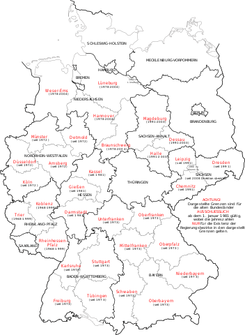
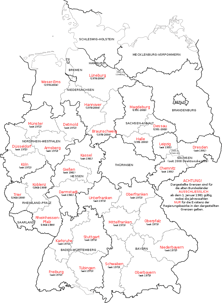
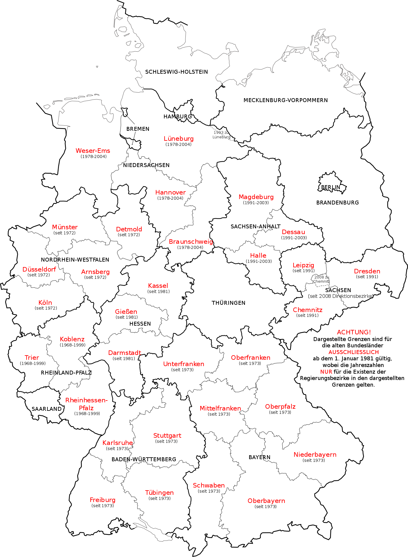
Deutsch: Karte der deutschen Regierungsbezirke und Direktsionsbezirke sowie ehemaliger Regierungsbezirke in Niedersachsen, Sachsen-Anhalt und Rheinland-Pfalz.
English: Map in German language of Germany showing the boundaries of the Regierungsbezirke for FRG from January 1st 1981 and for Germany till 2008. Also displayed are the former RB of Lower Saxony, Rhineland-Palatinate and Saxony-Anhalt.
Русский: Карта административных округов земель Германии и бывших административных округов в землях Нижней Саксонии, Саксонии, Саксонии-Ангальт и Рейнланд-Пфальц. |
| Data | |
| Origine | Own work, map derived from the image Kfz-Kennzeichen Deutschlands.svg |
| Autor | Bennet Schulte |
| Altere versiones | Derivative works of this file: Deutsche Rentenversicherung - Regionalträger 2006.svg |
Licentia
Io, titular del derecto de autor sur iste obra, declara de publicar lo sub le sequente licentias:
Iste file es disponibile sub le licentia Creative Commons Attribution-CompartiSimile 3.0 Non-localisate.
- Tu es libere:
- de condivider – de copiar, distribuer e transmitter le obra
- de remixar – de adaptar le obra
- Sub le sequente conditiones:
- attribution – Tu debe dar information appropriate sur le autor, fornir un ligamine al licentia, e indicar si modificationes ha essite apportate. Tu pote facer lo de qualcunque maniera rationabile, ma non in alcun modo que suggere que le licentiator approba te o tu uso del obra.
- condivider equalmente – Si tu altera, transforma o disveloppa le material, tu debe distribuer tu contributiones sub un licentia identic o compatibile con le original.

|
Le permission es concedite de copiar, distribuer e/o modificar iste documento sub le conditiones del Licentia GNU pro Documentation Libere, Version 1.2 o omne version plus recente publicate per le Fundation pro Software Libere; sin Sectiones Invariabile, sin Textos de Copertura Frontal e sin Textos de Copertura Posterior. Un copia del licentia es includite in le section titulate Licentia GNU pro Documentation Libere. |
Tu pote seliger le licentia de tu preferentia.
Historia del file
Clicca sur un data/hora pro vider le file como appareva a ille tempore.
| Data/Hora | Miniatura | Dimensiones | Usator | Commento | |
|---|---|---|---|---|---|
| actual | 15:23, 1 decembre 2017 | | 1 351 × 1 844 (1,5 MB) | Reinhard Kraasch | typo corr. |
| 14:30, 1 octobre 2009 |  | 1 351 × 1 844 (1,39 MB) | Exec | Amt Neuhaus eingebaut | |
| 13:19, 30 septembre 2009 |  | 1 351 × 1 844 (1,39 MB) | Exec | Embedded Font again | |
| 13:17, 30 septembre 2009 |  | 1 351 × 1 844 (183 KB) | Exec | Reverted to version as of 13:08, 30 September 2009 | |
| 13:16, 30 septembre 2009 |  | 1 351 × 1 844 (1,39 MB) | Exec | SVG Font embedding optimzed | |
| 13:08, 30 septembre 2009 |  | 1 351 × 1 844 (183 KB) | Exec | Arial Font | |
| 12:49, 30 septembre 2009 |  | 1 351 × 1 844 (183 KB) | Exec | {{Information |Description={{en|1=Map in German language of Germany showing the boundaries of the Regierungsbezirke for FRG from January 1st 1981 and for Germany till 2008. There are also shown the former RB of Lower Saxony, Rhineland-Palatinate and Saxon |
Uso de iste file
Il non ha paginas que usa iste file.
Uso global de iste file
Le altere wikis sequente usa iste imagine:
- Uso in ast.wikipedia.org
- Uso in az.wikipedia.org
- Uso in de.wikipedia.org
- Uso in de.wiktionary.org
- Uso in el.wikipedia.org
- Uso in es.wikipedia.org
- Uso in frr.wikipedia.org
- Uso in hu.wikipedia.org
- Uso in ka.wikipedia.org
- Uso in ky.wikipedia.org
- Uso in li.wikipedia.org
- Uso in pfl.wikipedia.org
- Uso in pl.wikipedia.org
- Uso in ru.wikipedia.org
- Uso in sco.wikipedia.org
- Uso in sv.wikipedia.org
- Uso in tr.wikipedia.org
- Uso in vi.wikipedia.org