File:Roman Empire (orthographic projection).svg

Dimension de iste previsualisation PNG de iste file SVG: 550 × 550 pixels. Altere resolutiones: 240 × 240 pixels | 480 × 480 pixels | 768 × 768 pixels | 1 024 × 1 024 pixels | 2 048 × 2 048 pixels.
File original (File SVG, dimensiones nominal: 550 × 550 pixels, grandor del file: 555 KB)
Summario
| Description |
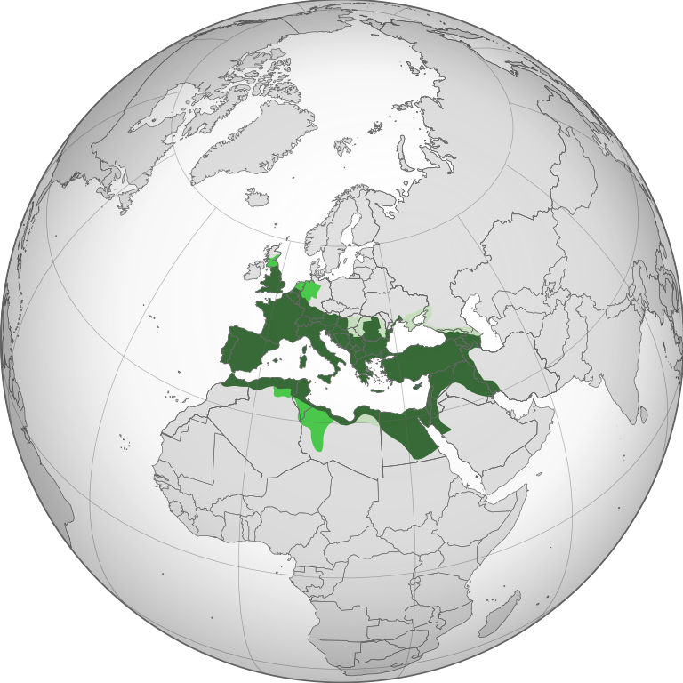
English: Roman Empire (orthographic projection) Roman Empire 117 CE Roman Client States 117 CE Roman Germania 9 CE, Roman Scotland 83 CE, Roman Libya 203 CE |
||||
| Data | |||||
| Origine |
Own work,
|
||||
| Autor | Heraldry | ||||
| Permission (Reuso de iste file) |
|
||||
| Altere versiones |
.svg) |
||||
| SVG genesis |

.svg)
.svg)
.svg)
.svg)
.svg)
.svg)
.svg)
.svg)
.svg)
.svg)
.svg)
.svg)
.svg)
.svg)
.svg)
.svg)
.svg)
.svg)
.svg)
.svg)
.svg)
.svg)
.svg)
.svg)
.svg)
.svg)
.svg)
.svg)
.svg)
.svg)
.svg)
.svg)
.svg)
.svg)
.svg)
.svg)
.svg)
.svg)
.svg)
.svg)
.svg)
.svg)
.svg)
.svg)
.svg)
.svg)
.svg)
.svg)
.svg)
.svg)
.svg)
.svg)
.svg)
.svg)
.svg)
.svg)
.svg)
.svg)
.svg)
.svg)
.svg)
.svg)
.svg)
.svg)
.svg)
.svg)
.svg)
.svg)
.svg)
.svg)
.svg)
.svg)
.svg)

.svg)

.svg)

.svg)
.svg)
.svg)
.svg)
.svg)
.svg)
.svg)


.svg)
.svg)
.svg)
.svg)
.svg)
.svg)
.svg)

.svg)
.svg)
.svg)
.svg)
.svg)
.svg)
.svg)
.svg)
.svg)

.svg)
.svg)
.svg)
.svg)
.svg)
.svg)
.svg)
_without_national_boundaries.svg)
.svg)
.svg)
.svg)
.svg)
.svg)
.svg)

.svg)
.svg)
.png)
.svg)
.svg)
.svg)
.svg)

.svg)
.svg)
.svg)
.svg)
.svg)
.svg)
.svg)
.svg)
.svg)
.svg)
.svg)

.svg)
.svg)
.svg)
.svg)
.svg)
.svg)
.svg)
.svg)
.svg)

.svg)
.svg)

.svg)
.svg)
.svg)
.svg)
.svg)
.svg)
.svg)
.svg)
.svg)
.svg)
.svg)
.svg)
.svg)
.svg)
.svg)
.svg)
.svg)
.svg)
.svg)
.svg)
.svg)
.svg)
.svg)
.svg)
.svg)
.svg)
.svg)
_-_Crimea_disputed.svg)
.svg)
.svg)
.svg)
.svg)
.svg)
.svg)
.svg)
.svg)
.svg)
.svg)
.svg)
_political.svg)
.svg)
.svg)
.svg)
.svg)
_-_Crimea_disputed_-_no_borders.svg)
.svg)
.svg)
.svg)
.svg)
.svg)
.svg)
.svg)
.svg)
.svg)
.svg)
.svg)

.svg)
.svg)
.svg)

.png)
.svg)
.svg)
.svg)
.svg)
.svg)
.svg)
.svg)
.svg)
.svg)
.svg)
.svg)
.svg)
.svg)
.svg)
.svg)
.svg)
.svg)
.svg)
.svg)
.svg)
.svg)
.svg)
.svg)
.svg)
.svg)
.svg)
.svg)
.svg)
.svg)
.svg)
.svg)
.svg)
.svg)
.svg)
.png)
.svg)
.svg)
.svg)
_(orthographic_projection).png)
.svg)
.svg)
.svg)
.svg)
.svg)
Licentia
Io, titular del derecto de autor sur iste obra, declara de publicar lo sub le sequente licentia:

|
Le permission es concedite de copiar, distribuer e/o modificar iste documento sub le conditiones del Licentia GNU pro Documentation Libere, Version 1.2 o omne version plus recente publicate per le Fundation pro Software Libere; sin Sectiones Invariabile, sin Textos de Copertura Frontal e sin Textos de Copertura Posterior. Un copia del licentia es includite in le section titulate Licentia GNU pro Documentation Libere. |
| Iste file es disponibile sub le licentia Creative Commons Attribution-CompartiSimile 3.0 Non-localisate. | ||
| ||
| Iste etiquetta de licentia esseva addite a iste file como parte del actualisation del licentia GFDL. |
Historia del file
Clicca sur un data/hora pro vider le file como appareva a ille tempore.
| Data/Hora | Miniatura | Dimensiones | Usator | Commento | |
|---|---|---|---|---|---|
| actual | 15:07, 21 april 2019 | | 550 × 550 (555 KB) | James2813 | Borders over the map. |
| 03:32, 23 januario 2014 |  | 550 × 550 (482 KB) | Spesh531 | adding white ocean | |
| 03:22, 23 januario 2014 |  | 553 × 553 (472 KB) | Spesh531 | adding on grid and gradient | |
| 03:20, 23 januario 2014 |  | 553 × 553 (472 KB) | Spesh531 | Adding client states, and areas claimed other then 117 CE. Much more exact | |
| 20:45, 4 augusto 2009 |  | 541 × 536 (498 KB) | TownDown | {{Information |Description={{en|1=Roman Empire (orthographic projection)}} |Source=trabajo propio (own work) |Author=TownDown |Date= |Permission= |other_versions= }} Category:Orthographic projections |
Uso de iste file
Le sequente pagina usa iste file:
Uso global de iste file
Le altere wikis sequente usa iste imagine:
- Uso in av.wikipedia.org
- Uso in be.wikipedia.org
- Uso in en.wikipedia.org
- Uso in es.wikipedia.org
- Uso in es.wiktionary.org
- Uso in eu.wikipedia.org
- Uso in fa.wikipedia.org
- Uso in hy.wikipedia.org
- Uso in inh.wikipedia.org
- Uso in it.wikipedia.org
- Uso in kbd.wikipedia.org
- Uso in ku.wikipedia.org
- Uso in os.wikipedia.org
- Uso in pt.wikipedia.org
- Uso in ru.wikipedia.org
- Uso in shi.wikipedia.org
- Uso in tt.wikipedia.org
- Uso in uk.wikipedia.org
- Uso in uz.wikipedia.org
- Uso in www.wikidata.org
- Uso in zh.wikipedia.org
.svg)