File:TokyoMapCurrent.png

Dimension de iste previsualisation: 800 × 400 pixels.Altere resolutiones: 320 × 160 pixels | 640 × 320 pixels | 1 280 × 640 pixels.
File original (1 280 × 640 pixels, dimension del file: 54 KB, typo MIME: image/png)

|
File:TokyoMap.svg is a vector version of this file. It should be used in place of this PNG file.
File:TokyoMapCurrent.png → File:TokyoMap.svg
For more information, see Help:SVG. |
 |
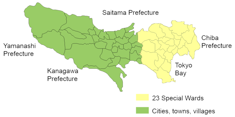
English: Map of mainland portion of Tokyo showing neighboring prefectures and Tokyo Bay
Deutsch: Karte der Präfektur Tokio, Gelb: die 23 Sonderbezirke; Grün: umliegende Gemeinden
Thanks to Aoki Shigenobu and [1]
Other versions:
- Italian: Image:TokyoMapCurrent it.png

|
Shigenobu AOKI, the copyright holder of this work, allows anyone to use it for any purpose including unrestricted redistribution, commercial use, and modification. |
Historia del file
Clicca sur un data/hora pro vider le file como appareva a ille tempore.
| Data/Hora | Miniatura | Dimensiones | Usator | Commento | |
|---|---|---|---|---|---|
| actual | 20:29, 23 septembre 2006 | | 1 280 × 640 (54 KB) | JR98664 | |
| 01:55, 24 april 2005 |  | 1 440 × 801 (43 KB) | Fg2 | Replaced color in key | |
| 11:52, 23 april 2005 |  | 1 440 × 801 (43 KB) | Fg2 |
Uso de iste file
Il non ha paginas que usa iste file.
Uso global de iste file
Le altere wikis sequente usa iste imagine:
- Uso in en.wikipedia.org