File:Un-guatemala.png
Dimension de iste previsualisation: 507 × 599 pixels.Altere resolutiones: 203 × 240 pixels | 406 × 480 pixels | 650 × 768 pixels | 866 × 1 024 pixels | 2 493 × 2 947 pixels.
File original (2 493 × 2 947 pixels, dimension del file: 1,8 MB, typo MIME: image/png)
| This image is a map derived from a United Nations map.
Unless stated otherwise, UN maps are to be considered in the public domain. This applies worldwide. UN maps are, in principle, open source material and you can use them in your work or for making your own map. UN requests however that you delete the UN name, logo and reference number upon any modification to the map. Content of your map will be your responsibility. You can state in your publication, if you wish, something like: based on UN map … (map name, map number, revision number and date). See: Geospatial Information Section. And: Geospatial, location data for a better world. |
 |
| Description |
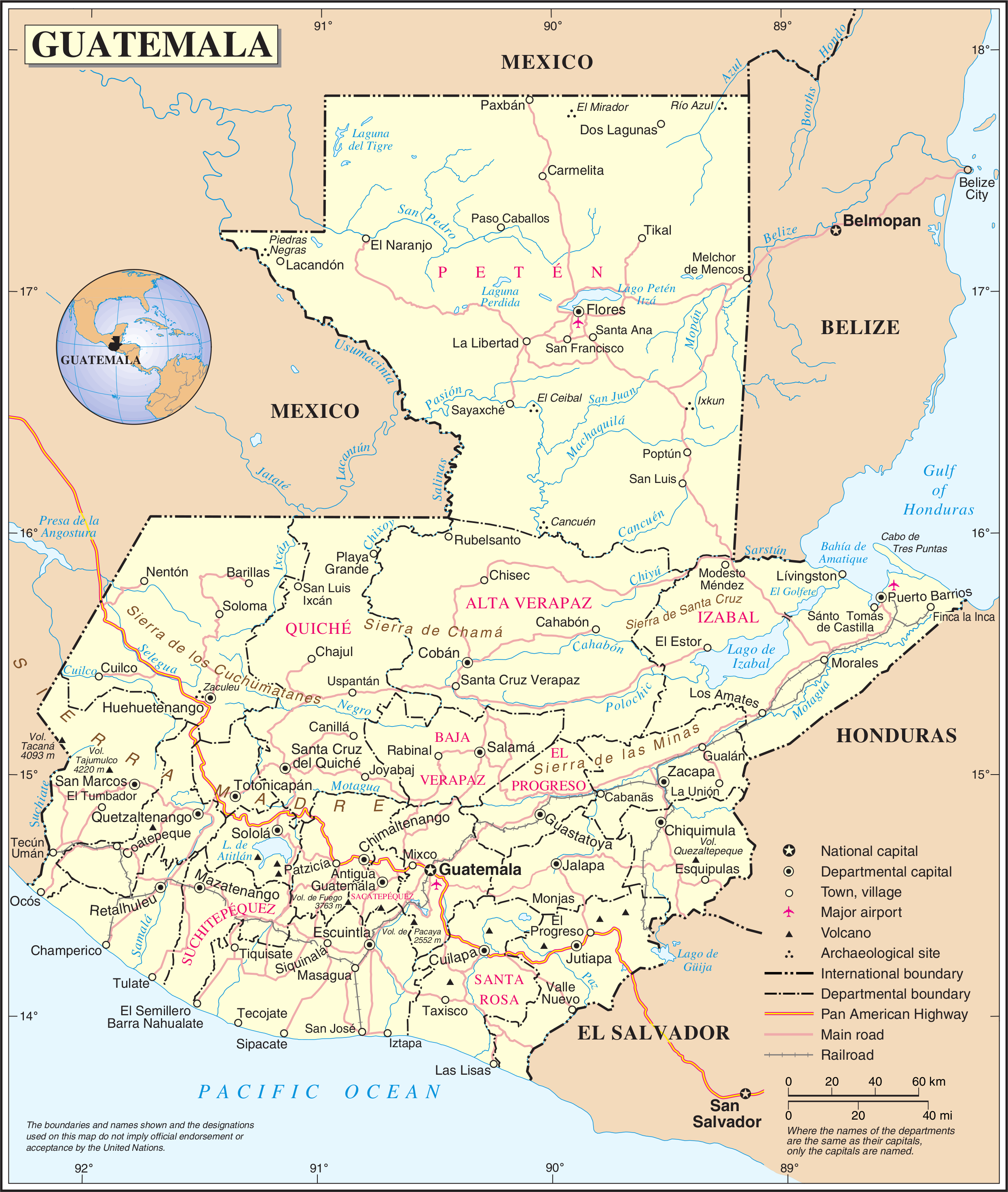
English: Political map of Guatemala generated by the United Nations. |
| Data | |
| Origine | United Nations Geospatial Information Section |
| Autor | United Nations Department of Peacekeeping Operations Cartographic Section |
Historia del file
Clicca sur un data/hora pro vider le file como appareva a ille tempore.
| Data/Hora | Miniatura | Dimensiones | Usator | Commento | |
|---|---|---|---|---|---|
| actual | 01:04, 24 octobre 2007 | | 2 493 × 2 947 (1,8 MB) | Jeroen | {{UN map}} Category:Maps of Guatemala |
Uso de iste file
Il non ha paginas que usa iste file.
Uso global de iste file
Le altere wikis sequente usa iste imagine:
- Uso in af.wikipedia.org
- Uso in ar.wikipedia.org
- Uso in be-tarask.wikipedia.org
- Uso in ckb.wikipedia.org
- Uso in el.wikipedia.org
- Uso in en.wikipedia.org
- Geography of Guatemala
- List of places in Guatemala
- Carlos Castillo Armas
- 1954 Guatemalan coup d'état
- Water supply and sanitation in Guatemala
- Outline of Guatemala
- Guatemala
- List of rivers of Guatemala
- Index of Guatemala-related articles
- Water resources management in Guatemala
- United Nations Security Council Resolution 1094
- User:Nlyemica/sandbox
- Uso in es.wikipedia.org
- Uso in fa.wikipedia.org
- Uso in fi.wikipedia.org
- Uso in gom.wikipedia.org
- Uso in id.wikipedia.org
- Uso in kbp.wikipedia.org
- Uso in kn.wikipedia.org
- Uso in lez.wikipedia.org
- Uso in mzn.wikipedia.org
- Uso in nl.wikipedia.org
- Uso in pl.wiktionary.org
- Uso in ro.wikipedia.org
- Uso in ru.wikipedia.org
- Uso in sl.wikipedia.org
- Uso in ta.wikipedia.org
- Uso in te.wikipedia.org
- Uso in to.wikipedia.org
- Uso in uk.wikipedia.org
- Uso in uk.wiktionary.org
Vider altere usos global de iste file.